Middle Fork Cimarron 
Distance: 6.2 - 11.0 miles (round trip)
Uncompahgre Wilderness Area, Uncompahgre National Forest, near Ouray in Southwest Colorado
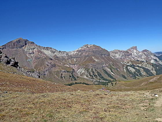
Peaks towering above the west side of the valley
View of Dunsinane Mountain, Precipice Peak, Redcliff Peak and Coxcomb Peak accompany hikers on this long hike up the scenic Middle Fork Cimarron Valley. A final steep climb leads to Middle Fork Pass with spectacular views of Uncompahgre, Wetterhorn and Matterhorn Peaks.
See Trail Detail/Full Description
- Distance: 11.0 miles (round trip) to Middle Fork Cimarron
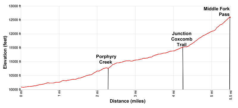
- Elevation: 10,080-ft. at Trailhead
12,595-ft. at Middle Fork Cimarron - Elevation Gain: 2,515-ft. to Middle Fork Cimarron
- Difficulty: moderate-strenuous
- More Hikes in:
Ouray / Southwest Colorado
Why Hike Middle Fork Cimarron
Get an early start to enjoy this long hike up the beautiful Middle Fork Cimarron Valley. The hike is accompanied by delightful views of the valley’s peaks and slopes, sculpted by wind and water into photogenic hoodoos, spires, pinnacles and rock formations.
Initially the trail ascends on easy to moderate grades through trees and small meadows. Openings offer fine view of Turret Ridge, Dunsinane Mountain and Precipice Peaks. After four miles the path breaks from the trees and views open to the cirque towering above the head of the valley, anchored by Fortress Peak, Redcliff Peak, Coxcomb Peak and the Heisshorn.
The path now travels through alpine meadows before curving to the southeast and climbing on moderately-steep to steep grades to Middle Fork Pass. Along the way enjoy far reaching views of the peaks rimming the west side of the valley. From the pass glorious views extend south/southeast to Uncompahgre Peak (14,309-ft.), Wetterhorn Peak (14,015-ft) and Matterhorn Peak (13,590-ft.).
The long, scenic drive to the trailhead from Ouray takes over an hour and a half. The road to the trailhead and the area around the trailhead offer camping opportunities. The hike can also be turned into a backpack by combining the Middle Fork with the East Fork Cimarron trail or continuing over the Middle Fork Pass to explore area 14ers along with the East Fork and Matterhorn Valleys.
Elevation Profile
| Buy the BookThis opinionated guide includes all the hikes in the Ouray, Telluride, Silverton and Lake City sections of the website plus info on local services and nearby attractions. |
Trail Resources
Trail Detail/Full Description / Trail Photo Gallery / Trail Map
Basecamp(s) Information:
Ouray
Region Information:
Southwest Colorado
Other Hiking Regions in:
Colorado