Old Railroad Grade 
Distance: 2.3 miles
San Juan National Forest, near Telluride in Southwest Colorado
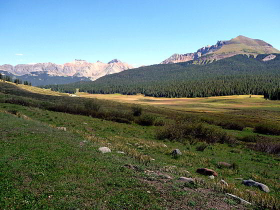
View toward the Trout Lake Area
The 2.25-mile unmarked Railroad Grade route, linking the Cross Mountain trailhead to the Lizard Head trailhead, enables hikers to complete a great 11.7 mile loop over Black Face Mountain to the base of the Lizard Head spire in the Lizard Head Wilderness. The walk may also be of interest to people looking for a nice easy stroll from the Lizard Head Pass parking area or the Cross Mountain trailhead.
- Distance: 2.3 miles (One Way)
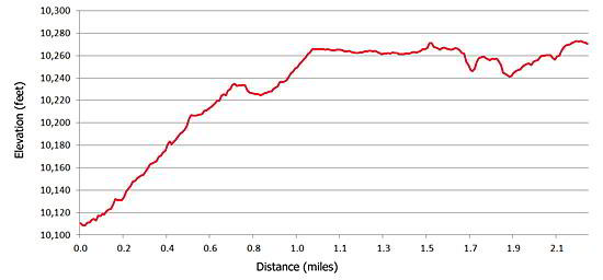
- Elevation: 10,040-ft. at Trailhead
Maximum elevation - 10,280-ft. - Elevation Gain: 240-ft.
- Difficulty: easy
- Basecamp: Telluride
- Region: Southwest Colorado
Trail Description - Old Railroad Grade
One of the great hikes in the Telluride area is the 11.7-mile Lizard Head loop. The trail, which starts just off of Highway 145 at Lizard Head Pass, traverses the panoramic spine of Blackface Mountain on its way to the base of Lizard Head peak (13,113-ft.), an eroded 400-ft tall spire shaped like the gaping maw of a lizard with its face to the sky. At the base of Lizard Head the trail meets the Cross Mountain trail, which drops down to Highway 145 just over 2-miles southwest of the pass.
Hikers complete the loop by walking 2.25 miles back to the Lizard Head trailhead on the unmarked former railroad bed of the Rio Grande Southern Railroad. In its heyday the narrow gauge railroad linked Durango, Colorado to Ridgway, Colorado, crossing 10,222-ft Lizard Head Pass en route to Placerville and ultimately Ridgway over Dallas Divide. The railroad ceased operation in 1951.
Hikers descending the Cross Mountain trail seeking to return to the Lizard Head trailhead should look for a wide, dirt path leading left (northeast) about 0.1 miles before the Cross Mountain trailhead parking area. Follow the unmarked path through meadows as it swings away from the highway to avoid a small drainage. Red metal markers, warning people not to dig in the area due to buried high voltage power lines, appear at intervals along the first half of the route.
The trail ascends gently, essentially paralleling the highway and offering nice views of Black Face Mountain and the peaks around Trout Lake, including Sheep Mountain, Vermilion Peak, Golden Horn and Pilot Knob. As you progress the dirt route turns to grass, but the way is always clear. At 0.9 miles skirt a metal barrier across the trail intended to block further vehicle access.
In slightly over a mile from the start the trail levels out and only experiences minor ups and downs for the remainder of the walk. Shortly after this point the trail swings toward the highway and stays about 75-yards from the artery until you reach the access road to the Lizard Head Pass parking area. Walk up the access road to where you left your vehicle.
For more information on the loop trail see the Lizard Head and Cross Mountain trail descriptions.
Elevation Profile
Driving Directions
Driving directions from Telluride to Lizard Head trailhead: Drive south from Telluride on Colorado 145 for 12.3 miles to Lizard Head Pass. On the right (west) side of the highway is a rest area and interpretive site. Turn right into the rest area and park. To find the unmarked trailhead walk to the southwest end of the parking area and proceed down the access road toward the highway. The trail takes off to the right about 100 yards before the road meets Highway 145.
Driving directions from Telluride to Cross Mountain trailhead: Drive south from Telluride on Colorado 145 over Lizard Head Pass (12.5-miles). Continue south for 2.2 miles and turn right onto a dirt road signed for the Cross Mountain trailhead. Walk up the Cross Mountain trail for about 0.1 miles and look for a wide, unmarked dirt track heading right (northeast). This is the railroad grade route.
Trail Resources
- Trail Photo Gallery
- Trail Maps
- Basecamp(s) Information: Telluride
- Region Information: Southwest Colorado
- Other Hiking Regions in: Colorado