Avalanche Lake 
Distance: 6.0 miles
Glacier National Park, near West Glacier in Glacier Natl Park, MT
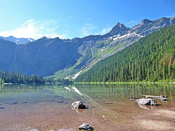
Avalanche Lake
This popular hike, traveling through a forest of red cedars, larches and western hemlocks, leads to photogenic Avalanche Lake. The first section of the hike enjoys fine views of Avalanche Creek. For more great views of Avalanche Creek, return via the Trail of the Cedars.
- Distance: 6.0 miles (RT)
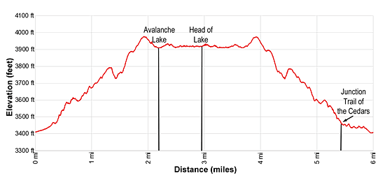
- Elevation: 3,405-ft. at Trailhead
Maximum elevation - 3,980-ft. - Elevation Gain: 575-ft.
- Difficulty: easy-moderate
- Basecamp: Lake McDonald
- Region: Glacier Natl Park, MT
Trail Description - Avalanche Lake
From the trailhead parking area near the Avalanche Lake Campground (see driving directions below), turn right on the trail to Avalanche Lake. Soon the trail starts climbing. At 0.3 miles reach a junction. Here the Avalanche Trail branches right (south) and heads back to Lake McDonald. To the left (north) is the Trail of the Cedars Loop. We continue straight ahead on the trail to Avalanche Lake.
Beyond the junction the trail continues ascending through the forest. At times the trail nears Avalanche creek, rushing over and around interesting rock formations. At 1.3 miles openings in the trees offer views of Bearhat Mountain (8,684-ft.), towering above the valley to the west, and the Hidden Creek drainage between Bearhat and Mount Cannon (8,953-ft.).
Reach the high point on the trail at 1.9 miles. From here the trail descends to the foot of lovely Avalanche Lake (3,905-ft.), sitting at the base of the Avalanche Basin, at 2.2 miles. Views open to the sheer cliffs of the cirque ringing the head of the basin. The Little Matterhorn (7,886-ft.), a pyramid shaped peak, rises along the ridge to the south. Unseen beyond the Little Matterhorn is the Sperry Glacier, feeding meltwater to Monument Falls and many of the other waterfalls spilling down the steep cliffs beyond the lake. Nearer at hand is a log jam at the lake’s outlet.
The area around the foot of the lake can get quite crowded. It is best to hike the trail early in the day to avoid the worst of the crowds. For a little more solitude follow the trail along the west side of the lake to the head of the lake at 2.9 miles. Here several inlet streams carrying water from the falls flow into the lake. Heavens Peak (8,987) dominates the view to the north.
After enjoying the lake, walk back along the trail. At 5.4 miles reach the junction with the Trail of the Cedars Loop. Turn right following the trail as it crosses a bridge over the creek and then travels along boardwalks through old growth forests in Avalanche Gorge. Along the way enjoy the weird and wonderful rock formation along the gorge.
At 5.8 miles the trail reaches the Going-to-the-Sun Road. Turn left, cross the bridge over Avalanche Creek and then follow the west side of the Trail of the Cedars Loop back to your vehicle for a 6.0 miles RT hike.
If starting from the Trail of the Cedars Parking area or the Avalanche Creek Parking area, crossing the Going-to-the-Sun Road and follow the Trail of the Cedars along the west side of Avalanche Creek to the beginning of the Avalanche Lake trail.
Elevation Profile
Driving Directions
From West Glacier, MT: From the junction of US-2 and the Going-to-the-Sun Road, turn northwest on the Going-to-the-Sun Road and follow the road 2.0 miles. Turn right at the junction with the Apgar Visitor Center to stay on Going-to-the-Sun Road. Continue for 14.4 miles and then turn right (east) onto the spur road to the Avalanche Lake parking area and the Avalanche Lake Campground. Follow the spur road for 350-ft. to the parking area on the left. Additional parking is located along the left (west) side of the Going-to-the-Sun Road at the Avalanche Picnic Area (just before the spur road) and the Trail of the Cedars Parking area along the right (east) side of the Going-to-the-Sun Road, a short distance beyond the spur road.
The Avalanche Lake Trail and Trail of the Cedars are very popular hikes with congested parking areas. Get there early or take the shuttle bus from the Apgar Visitor Center, a better option during the height of the summer when parking is extremely limited.
Trail Resources
- Trail Photo Gallery
- Trail Maps
- Basecamp(s) Information: Lake McDonald
- Region Information: Glacier Natl Park, MT
- Other Hiking Regions in: Montana