Kandersteg (Sunnbuel) to Adelboden 
Distance: 7.3 miles (one way)
Bernese Oberland, near Kandersteg in The Bernese Oberland
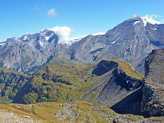
Doldenhorn and Altels
This challenging trail features panoramic views of the high peaks towering above the Spittelmatte, Uschene and Engstligenalp Valleys. The path is best suited for sure footed hikers who like demanding trails that cross exposed passes, travel along airy ridges and include steep ascents and descents.
See Trail Detail/Full Description
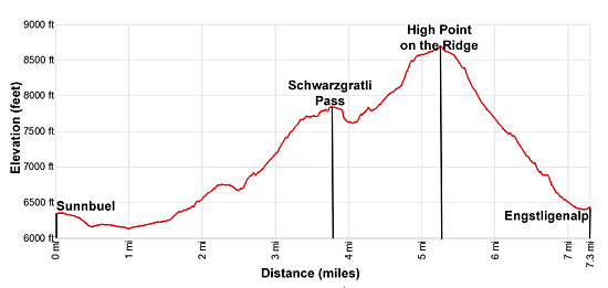
- Distance: 3.7 miles (one way) to Schwarzgratli Pass
7.3 miles (one way) to Engstligenalp - Elevation: 6,352-ft. at Trailhead
7,812-ft. at Schwarzgratli Pass
8,723-ft. at Engstligenalp - Elevation Gain: 1,460-ft. to Schwarzgratli Pass
2,959-ft. to Engstligenalp - Difficulty: strenuous
- More Hikes in:
Kandersteg / The Bernese Oberland
Why Hike Kandersteg (Sunnbuel) to Adelboden
At the head of the Kandertal (Kander Valley) to the south of Kandersteg lies Spittelmatte, a secluded, hanging valley, easily reached by taking the cable car to Sunnbuel. From Sunnbuel a path descends on easy grades to the pretty valley rimmed by Altels and the Rinderhorn to the east and the Uschenegrat ridge to the west.
A broad track travels through the valley and then ascends an old rockslide to the Hotel Schwarenbach. Here our trail turns west, climbing steeply to Schwarzgratli Pass on the Uschenegrat ridge. Along the way enjoy fine views of the high peaks and the ridge. As you crest the ridge terrific vistas open to the summits towering above the Uschene Valley to the west.
From the pass a steep, exposed, scree-covered trail descends to the Uschene Valley and then ascends an equally steep trail through rocky meadows to the crest of the Engstligengrat, the ridge separating the Uschene and Engstligenalp valleys. Atop the ridge views open to Engstligenalp, a pretty meadow-clad bowl ringed by high peaks.
The path now wanders north and then west along the high, airy ridge with glorious 360-degree views. Ahead the Tschingellochtighorn summit block rises along ridge. Pass to the south of the summit block and then descend steep scree-covered slopes and then meadows to Engstligenalp. At Engstligenalp a cable car whisks hikers down to Unter dem Birg where buses head to Adelboden and/or Kandersteg.
This trail offers an alternative, more demanding crossing to Adelboden than the traditional Alpine Pass Route from Kandersteg to Adelboden via the Bunderchrinde. After leaving the Spittelmatte Valley, you'll be well off the beaten path and find opportunities for short detours and explorations.
If you are uncomfortable with the descent from Schwarzgratli Pass, turn around and follow a trail north along the Uschenegrat ridge to a junction below the Gallihorn. From the junction descend to either Sunnbuel or the Uschene Valley and walk back to Kandersteg. It is also possible to walk back to Kandersteg by taking trails splitting off the Engstligengrat and Artelegrat ridges near the Tschingellochtighorn summit block.
Pick a day full of promise before setting out on this hike. The high ridges and exposed scree slopes should be avoided during thunderstorms, fog or slippery conditions. This trip is only recommended for experience, sure-footed hikers who delight in a challenging day that yields terrific, ever changing views.
Elevation Profile
| Support our Site |
Trail Resources
Trail Detail/Full Description / Trail Photo Gallery / Trail Map
Basecamp(s) Information:
Kandersteg
Region Information:
The Bernese Oberland
Other Hiking Regions in:
Switzerland