The Schwarzhorn, the Raduner Rothorn and Piz Radont
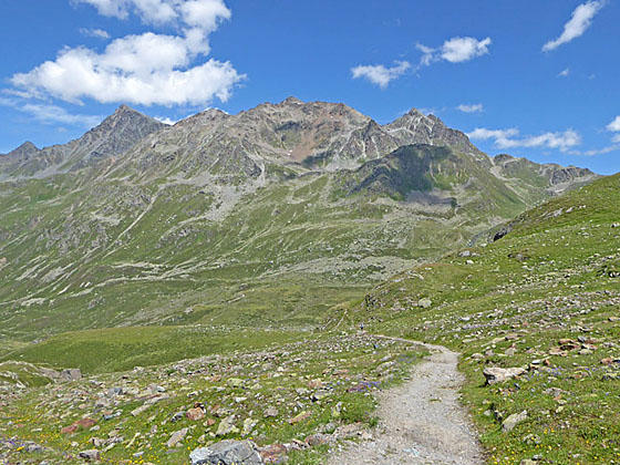
The trail to Scaletta Pass ascends through pastures, rocky meadows and then scree covered slopes with ever evolving views of high summits surrounding the photogenic valley. Highlights include the glacier-clad Scalettahorn, the Fluela Schwarzhorn massif and the peaks towering above Fuorcla da Grialetsch.
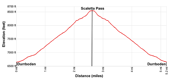
- Distance: 5.2 miles (RT)
- Elevation: 6,575-ft. at Trailhead
Maximum elevation - 8,547-ft. - Elevation Gain: 1,972-ft.
- Difficulty: moderate-strenuous
- Basecamp: Davos
- Region: Eastern Switzerland
Trail Description - Durrboden to Scaletta Pass
The lovely Dischma Valley, extending southeast from the Landwasser valley from Davos Dorf, is sprinkled with small villages set amid emerald green meadows beneath rugged peaks. Regularly scheduled buses travel to the Berggasthaus Durrboden, the last settlement near the head of the valley.
Above the Berggasthaus the valley branches into three lobes ringed by high summits. The Furgga Valley, with its lovely lake and the popular Grialetsch hut, lies to the east. The Scaletta Glacier spills down the slopes of the Scalettahorn and Piz Grialetsch in the aptly named Gletschtalli (Glacier Valley) to the southeast. Our trail to Scaletta Pass ascends southwest up the third lobe, the continuation of the Dischma Valley, rimmed by the Bocktenhorn, Leidhorn, Augstenhureli and Chuealphorn to the west and the Peak 2834 to the east.
To Scaletta Pass
Take the post bus from Davos to the Durrboden Restaurant (Berggasthaus Durrboden), the last stop in the Dischma Valley (see trailhead directions below). The historic Berghaus includes a nice restaurant with lovely views of the Scaletta Glacier, Piz Grialetsch, the Scalettahorn and neighboring peaks rising above the of the Gletschtalli. The Raduner Rothorn and Schwarzhorn tower above the valley to the east.
Walk along the east side of the Berghaus to the end of the car park. Here a trail signpost points to a broad track heading southeast through pastures up the Dischma Valley to Scaletta Pass. A short distance beyond the track splits. We bear right on the trail to Scaletta Pass. The trail to the left leads to the Grialetsch Hut, Fuorcla Radont (Radont Pass) and Fluela Ospiz. See the Durrboden to Fuorcla da Grialetsch and Fuorcla Radont hike for more information.
The trail soon crosses a bridge over the Furggabach (Furgga stream) and then ascends on moderate grades through pretty meadows between the Dischmabach (Dischma stream), to the west, and Furggabach, to the east.
At 0.4 miles go through a gate and then pass a small tarn near Gletschboden. A short distance beyond the grade steepens as the path ascends through rocky meadows scattered with shrubs. Ahead are fine views of the glacier-clad cirque, anchored by the Chilbiritzenspitz, Piz Grialetsch and the Scalettahorn, ringing the Gletschtalli Valley.
At 1.1 miles pass a junction with a trail branching left toward the Grialetsch Hut. Our path to Scaletta Pass now curves to the southwest, climbing through rocky meadows and then scree covered slopes beneath the west facing slopes of the Scalettahorn massif. A few switchbacks facilitate the climb.
Turn around for great views of the Raduner Rothorn and Schwarzhorn to the northeast. The Dischmabach tumbles down a rugged slope strewn with rock outcroppings to the west of the trail.
As you gain elevation views open to the Fuorcla da Grialetsch, the pass at the head of the Furgga Valley to the east. Piz Radont and the Chilbiritzenspitz rise above the pass. The Bocktenhorn, Leidhorn and Augstenhureli rise along the ridge above the west side of the trail. A small tarn at Seeboden lies nestled in the meadows along the valley floor. The Dischmabach cascades down a rugged cliff above the head of the tarn.
At 2.1 miles the grade briefly abates as the trail reaches a bench. Here the path travels through a rocky area. The trail builders having lovingly laid rock slabs along this section of the trail to ease the passage. Soon the climb resumes on moderately-steep grade up rocky meadows and rugged slopes.
At 2.4 miles the trail crosses the stream and then climbs a few steep switchbacks to Scaletta Pass (8,550-ft.) at 2.6 miles. The pass, a crossing on a medieval trade route between Chur, Davos and S-chanf, is a great place to take a break and enjoy the views of the rugged ridge, dominated by the Chlein Schwarzhorn, Schwarzhorn and Raduner Rothorn, towering above the east side of the Dischma Valley. To the south, Piz Musella, Piz Viluoch and Piz Griatschouls fill the skyline. The Chuealphorn and its glacier rise above the ridge to the southwest of the pass. (Walk a short distance down the south side of the pass for better views of the Chuealphorn.)
Just below the north side of the pass is a small shelter. In front of the shelter are several large, flat rocks – the perfect place for a picnic or a short break. When you are done enjoying the views retrace your steps to Durrboden. Alternatively, you can continue over the pass, descend through Alp Funtauna and then cross Sertig Pass to Sertig where buses return to Davos. See the Sertig to Durrboden hike for more information.
Elevation Profile
Driving Directions
Davos to Durrboden: From the Bahnhof (train station) at Davos Dorf (at the northeast end of town), board the bus to Durrboden. Get off bus at the last stop. The scenic ride up the Dischma Valley takes about 30 minutes. Regularly scheduled buses return to Davos via the same route. A schedule is posted at the bus stop at Durrboden. You can also check the current schedules at the SBB website/SBB app.
Note: Buses and trains travel between Davos Dorf and Davos Platz. The train ride takes three minutes. Buses take a variety of routes through the town. Pickup a bus schedule at the Tourism Office at the Davos Dorf Bahnhof or near the Sportzentrum in the middle of town, or consult the SBB website/SBB app to find the stop closest to your accommodations.
Trail Resources
- Trail Photo Gallery
- Trail Maps
- Basecamp(s) Information: Davos
- Region Information: Eastern Switzerland
- Other Hiking Regions in: Switzerland