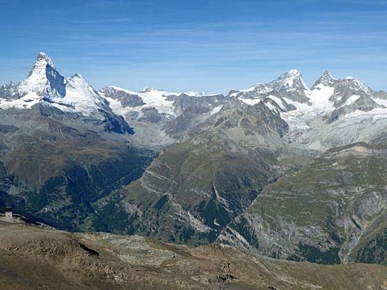
The Matterhorn and Dent Blanche at the head of the Zmutt Valley
The second highest hiking trail in Switzerland leads to the top of the Oberrothorn (11,200-ft.) with splendid 360-degree views of 38 peaks over 13,000-ft. (4,000-meters).
See Trail Detail/Full Description
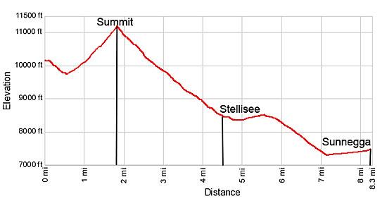
- Distance: 3.8 miles (round trip) to Oberrothorn
9.1 miles (round trip) to Oberrothorn to Sunnegga (Complete Hike) - Elevation: 10,162-ft. at Trailhead
11,190-ft. at Oberrothorn
7,217-ft. at Oberrothorn to Sunnegga (Complete Hike) - Elevation Gain: 1,400-ft. to Oberrothorn
-3,973-ft. to Oberrothorn to Sunnegga (Complete Hike) - Difficulty: strenuous
- More Hikes in:
Zermatt / The Valais
Why Hike Oberrothorn
Hikers climbing the strenuous trail to the top of the Oberrothorn (11,200-ft.) are rewarded with stunning, panoramic views of the 4,000-meter peaks surrounding the Zermatt area. From the summit enjoy glorious views of the Ober Gabelhorn-Weisshorn Group towering above the west side of the valley. The Mischabel Range dominates the view to the north while an incredible spectacle of peaks and glaciers, stretching from the Monte Rosa to the Breithorn massifs, fill the skyline to the south. The star of the show, the majestic Matterhorn, stands alone at the head of the valley.
Ski lifts facilitate the climb to the top while a good network of hiking trails allow parties to create interesting loop hikes incorporating a trip to the summit with visits to other scenic areas around the Oberrothorn massif. This hike rides the funicular to Sunnegga and then takes the gondola to Blauherd. From Blauherd it is 2.7 miles to the summit.
The Blauherd gondola connects with the Rothorn cable car that whisks hikers to the summit of the Unterrothorn, where a trails ascends the Oberrothorn in 1.9 miles. This description includes information on walking from the Blauherd and the Rothorn lift stations to the summit of the Oberrothorn. These relatively quick climbs to the summit are followed by a long descent that visits the Stellisee, the pretty meadows along the west facing slopes of the Unterrothorn and the small village of Tufteren.
Hikers looking for a more challenging day opt for the 7.4 mile (round-trip) hike from Sunnegga to the Oberrothorn that gains over 3,970-ft. The initial segment of this walk, from Sunnegga to the Blauherd lift station, is very steep and travels under or near the Blauherd gondola lines. My preference is to skip this segment and instead use the lifts to get to the summit early and then enjoy a leisurely day descending to Sunnegga.
The trail to the summit climbs through a barren landscape of rock and scree, with some exposure. It should not be attempted if the trail is covered with ice or slick snow unless parties are properly equipped. The hike is not recommended for families with small children or anyone with a fear of heights.
For the best views I strongly recommend getting an early start. Clouds can obscure views of the high peaks in the afternoon. The summit also gets quite crowded on a beautiful day given the easy access offered by the lifts.
The presence of the lifts and ski equipment along some trail segments certainly detract from the hike. While not optimal, it is easy to quickly pass through these eyesores and avoid trail segments traveling directly beneath the lift lines. I believe the fabulous views are adequate compensation for these blemishes upon an otherwise scenic landscape.
Elevation Profile
| Support our Site |

Trail Resources
Trail Detail/Full Description / Trail Photo Gallery / Trail Map
Basecamp(s) Information:
Zermatt
Region Information:
The Valais
Other Hiking Regions in:
Switzerland