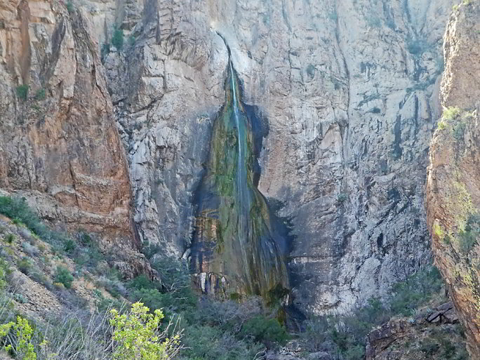
Window pour-off and waterfall
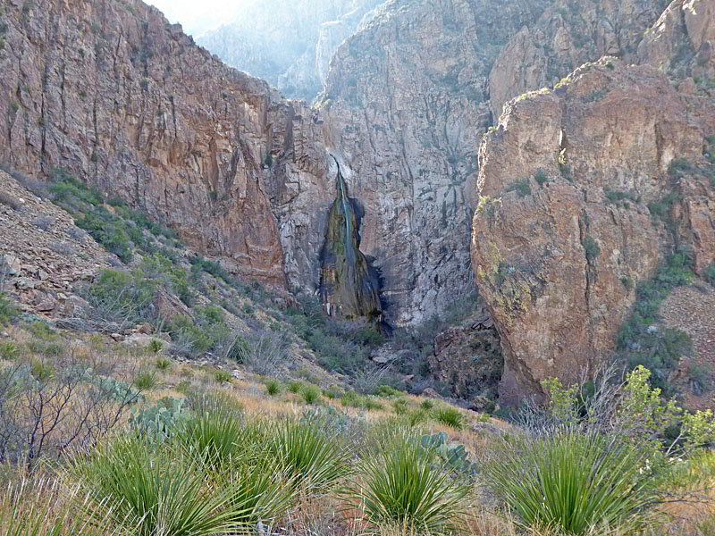
The Oak Spring trail features great views of the Window without the crowds. During wet periods a waterfall spills over the pour-off at the base of the Window. The hike is accompanied by panoramic views of the desert, Burro Mesa and the Chisos and Christmas Mountains.
- Distance: 2.2 - 6.4 miles (RT)
- Elevation: 3,845-ft. at Trailhead
Maximum elevation - 4,260-ft. - Elevation Gain: 415-ft.
- Difficulty: moderate
- Basecamp: Big Bend
- Region: Texas Parks
Trail Description - Oak Spring
Note: This trail has two possible starting points. A 1.3 miles gravel road leads from the Ross Maxwell Scenic Drive to the trailhead parking area. If the road is open and in good condition, hikers can start from this point. Otherwise, park along the Ross Maxwell Scenic Drive and walk the trailhead access road, adding 2.6 miles (round-trip) to the hike.
Two mileage numbers are provided in the hike description. The first is the mileage from the trailhead parking area and the second is the mileage from the Ross Maxwell Scenic Drive.

The Oak Spring trail offers an alternative and less crowded option for viewing the Window, a narrow gap in the peaks surrounding a high valley in the Chisos Mountains. At the base of the Window is a pour-off where, during wet periods, a seasonal waterfalls plunges 220-ft. down the west side of the Chisos Mountains.
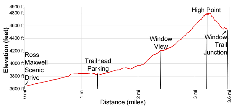
There are several possible turnaround points on the hike along with an option to combine the hike with the trail to Cattail Falls. The easiest option is to hike to the Windows View at 2.2/4.8 mile (round-trip) for nice vistas of the pour-off and the falls. From here the trail climbs to its high point at 3.8/6.4 miles (round-trip) with far reaching views of Burro Mesa to the west and the Christmas Mountains to the northwest.
Beyond the high point the path crosses a ridge and then visits an overlook high above the Windows Trail before descending to meet the Windows Trail at 2.3/3.6 miles (one way). From here a 0.5 miles round-trip spur trail leads to the edge of the pour-off. Hiker with a previously arrange car shuttle can then ascend the Windows Trail in the Visitor Center in the Chisos Basin in 2.75 miles for a 5.6/6.9 mile point to point hike.
Another fine option is to combine a visit to the Windows View or the high point with a trip to Cattail Falls. See the Cattail Falls hike for more information.
Starting From Ross Maxwell Scenic Drive
Distance: 4.8 - 6.4 miles (round-trip) Elevation Gain: 614-ft. – 1,144-ft.
The access road to the trailhead for this hike starts along the Ross Maxwell Scenic Drive just to the north of the Sam Nail Ranch. (See the driving directions below for more information.) From the Ross Maxwell Drive the gravel access road to the Oak Spring trailhead ascends on gentle grades through the Chihuahuan Desert accompanied by good views of the Chisos Mountains towering above the desert to the east while the Christmas Mountains rise to the north. To the west Burro Mesa dominates the skyline. The access road reaches the trailhead parking area in 1.3 miles.
Starting from the Trailhead Parking Area
Distance: 2.2 - 3.8 miles (round-trip) Elevation Gain: 415-ft. - 945-ft.
The access road to the trailhead for this hike starts along the Ross Maxwell Scenic Drive just to the north of the Sam Nail Ranch. (See the driving directions below for more information.) Just beyond the parking lot signs point up the gravel road toward the Window Trail via Oak Spring, Oak Spring and the Cattail Fall trails. Past the sign the trail quickly reaches a gate. Go around the gate and then ascend the gravel road through the Chihuahuan Desert on easy to moderately-easy grades.
Ahead are fine views of the Chisos Mountains and the Window, located in the V-shaped saddle between Vernon Bailey Peak (the rounded peak) and Carter Peak (the triangular peak). The Christmas Mountains are seen in the distance to the northwest.
At 0.5/1.8 miles the trail descends into the Oak Creek drainage, clad in trees and shrubs. A short distance beyond a large Oak tree and a sign mark the junction with the trail to Cattail Falls, branching right. We bear left on the Oak Spring Trail that continues along the road toward the Window. In a short distance the road crosses the Oak Creek wash, which may contain water.
The road now climbs out of the wash and soon curves to the right (southeast), ascending on steeper grades to a junction at 0.9/2.2 miles. Ahead the road is blocked and a fenced area keeps hikers away from a water storage tank and Oak Spring.
Oak Spring, a year-round water source located within the fenced area, is used by the Park Service to supply water to the Chisos Basin area. Water from the spring is channel into the tank and then pumped uphill to the basin. There is no access to the spring or the storage facility.
At the junction we turn left on the signed Oak Spring trail toward the Window. The path briefly heads north before turning east/northeast, climbing on steeper grades up the hillside along the north side of Oak Creek Canyon. As you ascend turn around for good views of Burro Mesa rising to the west.
At 1.1/2.4 miles the grade briefly abates. You are now slightly above the basin at the base the Window’s pour-off. Ahead are views of the Window pour-off and the falls, if water is present. This is a good turnaround point for parties looking for a shorter day or hikers who want to combine this hike with the trail to Cattail Falls .
Hikers who wish to climb higher, visit the Window or have a previously arrange car shuttle should continue up the trail. The path soon resumes ascending on moderately-steep to steep grades up the west facing flanks of Vernon Bailey Peak. At 1.45/2.75 miles the trail starts up a series of switchbacks, passing a jagged tower along the way.
At 1.8/3.1 miles the trail swings to the right (south/southeast) and follows an undulating course atop rugged cliffs, reaching a high point at 1.9/3.2 miles. Views atop the cliff extend down Oak Spring Canyon. To the west is Burro Mesa and, in the distance, the cliffs rising above the Rio Grande around Santa Elena Canyon. To the northwest are great views of the Christmas Mountains.
Past the high point the trail crosses a ridge extending southwest from Vernon Bailey Peak at 2.0/3.3 miles and then turns to the southeast as it descends along steep slopes. A short distance beyond a short spur trail, branching right, leads to an overlook. Here Carter Peak towers overhead across the canyon. Carefully look over the edge to see the Window Trail far below the overlook.
Beyond the overlook the trail descends along a steep slope to a junction with the Window Trail at 2.3/3.6 miles. Turn right at the junction and follow the Windows Trail as it descends along the wash to the Window. Return to the junction when you are done enjoying the Window. Total distance to the Window and back is 0.5 miles (round-trip).
From the junction the Windows trail ascends for 2.75 miles to the Visitor Center in Chisos Basin. Total distance for the point to point hike is 5.6/6.9 miles. See the Window Trail for more information about this segment of the trail.
Elevation Profile
Driving Directions
From the Big Bend National Park Headquarters at Panther Junction: From Panther Junction, at the intersection of the Persimmon Gap Road and the West Entrance Road, head west on the West Entrance (Gano Springs) road toward Basin Junction. Follow the road for 12.7 miles and then turn left on the Ross Maxwell Scenic Drive. Drive 3.3 miles on the Ross Maxwell road and turn left (east) onto the unmarked Oak Spring Road. (If you come to the pull-out for the Sam Nail Ranch you missed your turn.) Follow the gravel Oak Spring Road for 1.3 miles to the trailhead parking area on the north side of the road.
The road is typically OK for passenger cars. Check at the ranger station for road conditions and to determine if the road is open. If you need to walk from Ross Maxwell Drive to the trailhead at 1.3 mile (one-way) to the distances in the trail description.
From the Chisos Mountain Lodge Area: Head northeast on Chisos Basin Road for 6.4 miles and then turn left onto the West Entrance Road. Follow the West Entrance Road for 9.5 miles and the turn left onto the Ross Maxwell Scenic Drive. Drive 3.3 miles on the Ross Maxwell road and turn left (east) onto the unmarked Oak Spring Road. (If you come to the pull-out for the Sam Nail Ranch you missed your turn.) Follow the gravel Oak Spring Road for 1.3 miles to the trailhead parking area on the north side of the road.
The road is typically OK for passenger cars. Check at the ranger station for road conditions and to determine if the road is open. If you need to walk from Ross Maxwell Drive to the trailhead at 1.3 mile (one-way) to the distances in the trail description.
Trail Resources
- Trail Photo Gallery
- Trail Maps
- Basecamp(s) Information: Big Bend
- Region Information: Texas Parks
- Other Hiking Regions in: Texas