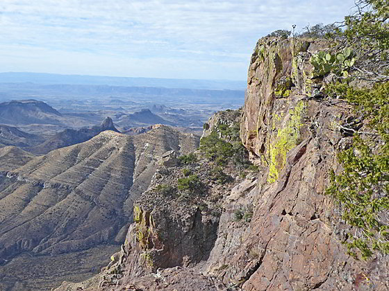
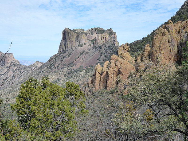
Sheer cliffs along the south rim
This long, strenuous hike features panoramic views of the Chisos Mountains and the Sierra Quemada range along with distant vistas of the high cliffs towering above the Rio Grande, the mouth of Santa Elena Canyon and nearby peaks in Mexico.
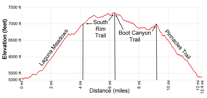
- Distance: 12.4 miles (RT)
- Elevation: 5,320-ft. at Trailhead
Maximum elevation - 7,350-ft. - Elevation Gain: 2,030-ft.
- Difficulty: strenuous
- Basecamp: Big Bend
- Region: Texas Parks
Trail Description - South Rim Loop
Note: There is a lot of up and down along the trail making the elevation gain and loss well above 3,200-ft.
This South Rim Loop trail starts at the Chisos Basin Trailhead near the Visitor Center. (See driving directions below). The path heads south/southwest through brush for 0.25 miles to the junction of the Pinnacles and Laguna Meadows Trail. The loop can be walked in either direction. This description ascends the Laguna Meadow Trail providing a more gradual climb to the South Rim than the Pinnacles Trail. Backpackers often walk in the option directions to reach the Boot Canyon Spring early in the hike.
Laguna Meadows Trail
Day hikers should bear right on the Laguna Meadows trail. The undulating path soon turns west accompanied by fine views of the peak rimming the north end of the Chisos Basin. The Window is seen between Carter Peak and Vernon Bailey Peak. Peak 6847 dominates the view to the west.
At 0.4 miles the path curves to the south and soon starts climbing on easy to moderately-easy grades, reaching a junction at 0.7 miles. To the left is a connector trail that leads east to the Pinnacles trail. Turn around here for more good views of the peaks to the north.
We continue straight on the Laguna Meadows trail that ascends through brush and trees. Openings offer fine views of Peak 6847 to the west. As you climb the vegetation thickens, restricting the views.
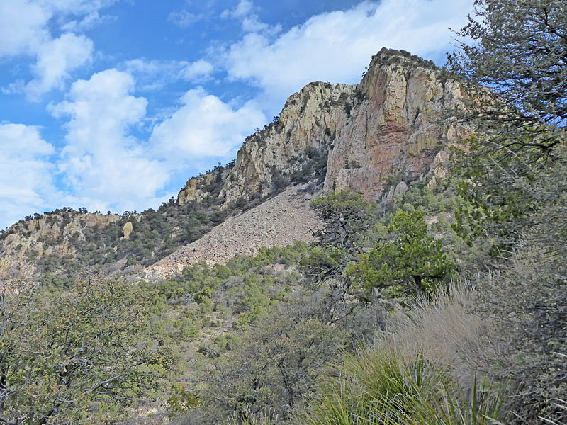
At 1.3 miles the grade becomes steeper as the trail climbs a series of switchbacks on moderate to moderately-steep grades beneath the southwest facing slopes of Emory Peak. Behind you are more far reaching views of the peaks rimming the north end of the Chisos Basin.
At 3.1 miles the grade abates as the trail crests a saddle on a ridge between two hills. Turn around for great views of the peaks to the north/northeast including Casa Grande, Mount Huffman and Peak 6905. Beyond the saddle the undulating path traverse beneath the west facing slopes Emory Peak.
Reach a junction with the spur trail to the Laguna West camping area, branching right (west), at 3.3 miles. A short distance beyond the junction the path resumes its climb and soon passes the Laguna Meadows camping area where the path curves to the left (southeast).
Pass the junction with Blue Creek Canyon trail, branching right (south), at 3.5 miles. The trail, part of the Outer Mountain Loop Backpack, descends to the Homer Wilson Ranch near the Ross Maxwell Scenic Drive where it connects with the Dodson Trail. We continue ascending on the Laguna Meadows trail toward the Colima Trail.
The path now climbs a switchback, cresting the top of a ridge at 3.7 miles. Here views encompass the high peaks rimming the south side of Blue Creek Canyon. The next switchback features views of Emory Peak to the northeast.
South Rim Trail
Reach a junction and the end of the Laguna Meadows trail at 4.1 miles. To the left is the Colima Trail providing a short-cut to the Boot Springs trail. We bear right on the South Rim Trail, which ascends high above the east side of Blue Springs Canyon. Peak 7150 and Peak 6728 rise above the canyon to the west/southwest. Behind you are more good views of Emory Peak.
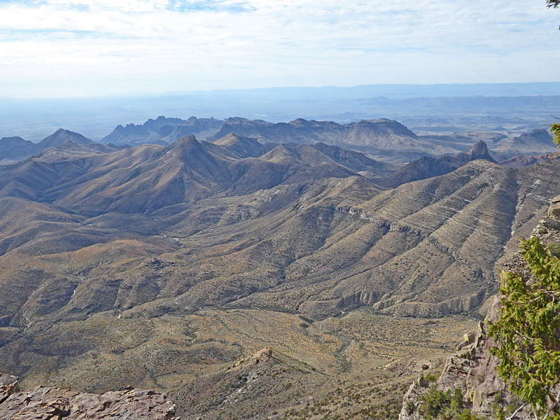
Soon the trail curves to the left (east) as it climbs out of Blue Creek Canyon and then curves to the right (south). The path now travels atop or near the ridge crest separating Blue Creek Canyon, to the west, with Boot Creek Canyon, to the east. Views along this segment look into Boot Creek Canyon or extend southwest down the length of Blue Canyon to the high cliffs along the Rio Grande, the mouth of Santa Elena Canyon and the peaks in Mexico. As you travel south you will pass a few spur trails leading to campsites.
At 5.5 miles reach a junction with an unmarked trail branching right (southwest). The South Rim trails curves to the left (east). If time and energy permit, take the 0.35 mile (round-trip) detour along the unmarked spur trail that descends across a grassy plateau with panoramic views.
Along the spur trail and its overlooks views extend south to the lower mountains and hills of the Sierra Quemada (‘the Burning Mountain range” in Spanish). Some believe the circular formation of this range is due to a caldera that erupted and collapse. To the southwest views stretch to the high cliffs along the Rio Grande and beyond. To the north are fine views of Emory Peak.
After enjoy the views retrace your steps along the spur trail, returning to the junction with the South Rim trail at 5.85 mile. Follow the South Rim trail as it continues east/southeast along the Chisos rim with more superb vistas. An overlook along the rim at 6.1 miles features dramatic views of the sheer cliffs below the southeast rim.
Beyond the overlook the path descends on easy grades to a junction aand the end of the South Rim trail at 6.4 miles. Here we have a choice. To the right is the Northeast Rim trail which loops around the southeast rim and then the northeast rim trail before connecting with the Boot Canyon trail. This 3.3 mile segment offers fine views of the Sierra Quemada Range and the desert beyond. To the north/northeast are views of Juniper Canyon, Lost Mine Peak and Toll Mountain.
Be aware that the Northeast Rim trail may be closed in the late winter and/or the spring to protect nesting peregrine falcons. Closures notices will be posted at trail junctions. The best bet is to check with the Park Service about possible closure before starting the South Rim hike.
Alternatively bear left (northwest) at the junction on the Boot Canyon trail, which reaches the north end of the Northeast Rim trail in 0.9 mile. Adding the Northeast Rim trail to the loop adds 2.4 miles to the hike for a 14.8 mile day. This distance is too long for many day hikers.
Boot Canyon Trail
For this description we bear left at the junction on the Boot Canyon trail that descends on moderate grades, dropping to the floor of Boot Canyon at 6.8 miles. Depending on the time of year and recent rainfall a stream may be running down the canyon’s slickrock-clad wash.
The trail does not stay in the wash but instead crosses the adjacent benches to shortcut meanders along the creek. The canyon slowly grows deeper as you head down stream.
At 7.0 miles the canyon curves to the right (northeast). Here the trail descends along the canyon’s eastern slopes, avoiding vegetation and other obstacles in the wash. Along the way the path passes the northern end of the Northeast Rim trail at 7.3 miles.
At 7.7 miles the trail travels by the junction with Juniper Canyon, branching right. We continue heading down Boot Canyon toward the Pinnacles trail. The path soon crosses to the west side of the wash and soon reaches a second junction near an old cabin at 7.75 miles. Here a spur trail branches right to Boot Spring. We continue on the Boot Canyon trail in the direction of the Chisos Basin via the Pinnacles Trail.
At 7.8 miles pass a third junction with the Colima Trail. This trail links the Boot Canyon trail with the Laguna Meadows trail. A short distance beyond a spur trail branches right toward some campsites.
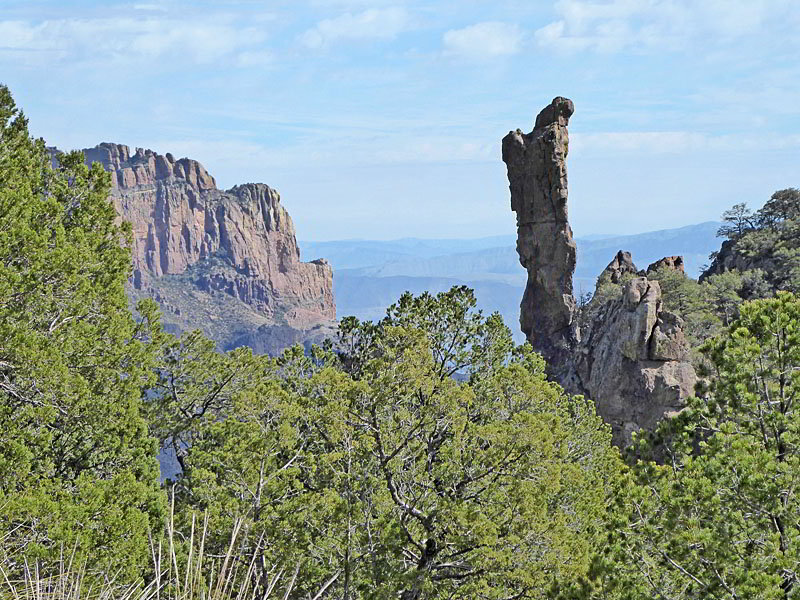
Our path now curves to the northwest, away from the wash, traversing the forested slopes above the west side of Boot Canyon. Here views open to the Boot, a volcanic spire that looks like an upside down boot, for which the canyon is named. At 8.5 miles the path curves to the right (northeast) on an undulating trail that descends gently along Boot Canyon’s western slopes. Here Crown Mountain, rising above Juniper Canyon, forms a beautiful backdrop for the Boot.
Soon the path swings to the left (northwest), climbing on moderate grades up the west side of a drainage to a junction just below a saddle. Here the Emory Peak trail branches right. This 3.0 mile round-trip to the summits gains almost 1,000-ft. I recommend summiting the peak on a separate day hike the climbs up the Pinnacles trail.
Pinnacles Trail
The junction with the Emory Peak trail marks the end of the Boot Canyon trail and the beginning of the Pinnacles trail. A short climb quickly leads to the saddle between Emory Peak and Toll Mountain at 8.9 miles.
Here view open to Vernon Bailey Peak and Peak 6847 rising above the northwest side of the Chisos Basin. The path now descends the steep slopes beneath the saddle on switchbacks, passing through a scenic area of jagged volcanic rock formations, pinnacles and hoodoos. Opening offer views of Emory Peak and the volcanic outcroppings along the peaks north facing flanks.
Past the first set of switchbacks the path descends steeply northwest to a ridge crest where fine views open to Casa Grande and Toll Mountain. Another series of switchbacks drops steeply down the slopes of the ridge, passing more volcanic outcroppings. Beyond the switchbacks the trail continues it steep descent into Boulder Meadows at 10.9 miles where the grade abates. A short distance beyond a spur trail branches right (east) to some back country campsites.
Another short descent soon leads to beautiful Juniper Flat, a grassy open area with terrific views of Casa Grande, at 11.3 miles. Here the grade briefly moderates as it passes through the flat and curves to the left (northwest), pass a few campsites.
Beyond Juniper Flat the trail resumes its descent, now on moderate to moderately steep grades, passing the Basin Loop trail at 11.8 miles and then some water tanks and housing. Reach the end of the Pinnacles trail and the loop at the junction with the Laguna Meadows trail at 12.1 miles. From here it is an easy walk back to the Chisos Basin trailhead at 12.4 miles.
Elevation Profile
Driving Directions
From the Big Bend National Park Headquarters at Panther Junction: From Panther Junction, at the intersection of the Persimmon Gap Road and the West Entrance Road, head west on the West Entrance (Gano Springs) road toward Basin Junction for 3.2 miles. Turn left on the Chisos Basin Road and follow the road for 6.3 miles to the Chisos Basin Visitor Center and park. The Chisos Basin trail starts along the west side of the parking area, just to the south of the Convenience store.
From the Chisos Mountain Lodge Area: Park or walk to the west side of the parking area near the Visitor Center and the Convenience Store. The Chisos Basin trail starts along the west side of the parking area, just to the south of the Convenience store.
Trail Resources
- Trail Photo Gallery
- Trail Maps
- Basecamp(s) Information: Big Bend
- Region Information: Texas Parks
- Other Hiking Regions in: Texas