Landscape Arch
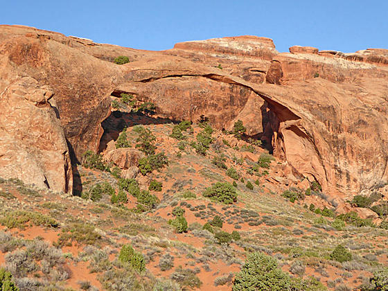
The broad, easy trail to Landscape Arch is popular and deservedly so. The spectacularly slender arch seeming defies gravity with its thinnest section, only 6-ft. thick, supporting a span of entrada sandstone that is 290-ft. long.
- Distance: 1.8 - 2.3 miles (RT)
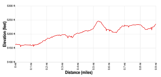
- Elevation: 5,150-ft. at Trailhead
Maximum elevation - 5,240-ft. - Elevation Gain: 90-ft.
- Difficulty: easy
- Basecamp: Arches / Moab
- Region: Southeast Utah
Trail Description - Landscape Arch
The Devils Garden trail in Arches National Park travels through a landscape of weird and wonderful sandstone fins, spires and knobs. The first 0.9 miles follows an easy, well grade path to graceful Landscape Arch, passing a side trail leading to Pine Tree and Tunnel Arches along the way.
Landscape Arch, one of the world’s longest rock spans, is a very popular destination in the park and is often quite crowded. Don’t let the crowds deter you. The easy hike to this remarkable arch, a slender ribbon of entrada sandstone with a span of 290-ft., is well worthwhile.
From the trailhead, located at the north end of the parking area (see driving directions below), follow the wide, well graded dirt/gravel path as it climbs northwest on gentle grades through sandstone fins. At 0.2 miles pass a short spur trail on the right (east) leading to Tunnel and Pine Tree Arches.
The detour to these two small arches is just over 0.5 miles round trip. To reach the arches descend along the spur trail for a short distance to a “Y” intersection. The trail to the right quickly leads to Tunnel Arch (25.5-ft. wide and 14-ft. high), a good example of a relatively young arch eroded entirely within a massive 14-ft. thick sandstone wall. The short hike to the left leads to Pine Tree Arch (46-ft wide and 48-ft. high), named for the Pinion Pine framed in its opening.
After viewing the two arches return to the main trail and continue ascending northwest on easy grades. At 0.8 miles pass a turnoff to the right (east) for the Primitive Loop.
Shortly past the junction reach the viewpoint for Landscape Arch, 0.9 miles from the trailhead. This graceful, 77-ft. high arch is one of the world’s longest stone spans, stretching 290-ft., yet is only 6-ft. thick at it center.
The arch was almost five feet thicker until September 1, 1991 when loud cracking and popping noises sent visitors sitting under the arch running. Soon small pieces of the arch began to fall and then a 60-ft. long slab of rock dropped from the underside of the arch’s thinnest section. When the dust settled 180-tons of fresh rock debris lay scattered beneath the arch. Thankfully no one was hurt. Due to safety concerns visitors are no longer permitted to hike beneath the arch.
Before leaving the viewpoint look up to see Partition Arch, located high on a sandstone wall to the right (northwest) of Landscape Arch.
Beyond Landscape Arch the Devils Garden trail becomes more challenging as it climb steeply up a slickrock ramp toward Double O Arch. For more information see the descriptions of the Double O Arch and the Devils Garden trails.
Elevation Profile
Driving Directions
From Moab: Drive northwest on US 191-N for 4.6 miles and turn right onto the Arches National Park Entrance Road. Travel along the road for 0.6 miles to the park entrance station where you pay park fees and obtain park brochures. (First time visitors should stop at the Visitor Center, located on the right 0.2 miles up the road from the Entrance Station to view the exhibits and obtain information about current park conditions.)
Beyond the entrance station drive 17.8 miles to the Devils Garden parking area at the end of the main road (now called the Arches Scenic Drive). Along the way pass turnoffs for the Windows Area at 9.3 miles and Delicate Arch at 11.5 miles. The trailhead is located at the north end of the parking area near a bulletin board and bathrooms. Note: The parking area fills quickly during busy periods.
Trail Resources
- Trail Photo Gallery
- Trail Maps
- Basecamp(s) Information: Arches / Moab
- Region Information: Southeast Utah
- Other Hiking Regions in: Utah