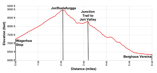
Wagerhus - Jorifluelafurgga - Berghaus Vereina 
Distance: 6.0 miles
near Davos in Eastern Switzerland
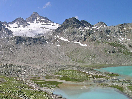
Fluela Wisshorn and the Jori Glacier
Stunning views of the Joriseen lakes, the Fluela Wisshorn and Jori Glacier await hikers climbing to Jorifluelafurgga. From the pass the trail descends to a beautiful lake basin and then drops down the lovely, untamed Jori Valley, ringed by high peaks, to the Berghaus Vereina.
- Distance: 6.0 miles (One Way)
- Elevation: 7,238-ft. at Trailhead
Maximum elevation - 8,930-ft. - Elevation Gain: 1,692-ft.
- Difficulty: moderate-strenuous
- Basecamp: Davos
- Region: Eastern Switzerland
Trail Description - Wagerhus - Jorifluelafurgga - Berghaus Vereina
A stiff climb to the scenic Jorifluelafurgga, a saddle on the ridge to the south of the Jorihorn, is amply rewarded with wonderful views of the photogenic Joriseen lakes and the high peaks towering above the Jori Valley and its tributary glens. From the pass the trail drops down to the lakes basin where hikers can wander among these turquoise-green jewels set against a backdrop of the Fluela Wisshorn and the Jori Glacier.
Finish the hike with a steep descent into the pretty meadows of the wild and pristine Jori Valley. Here lovely views stretching up the Suser Valley to Piz Linard and up the Vernela Valley to the glacier-clad Verstanclahorn.
A short section of the trail dropping down from the pass has some exposure. Fix cables safeguard this segment of the path.
Hiking from Wagerhus to Berghaus Vereina
Start the day with a post bus ride up the Fluela Pass road (Fluelapassstrassa) to the Wagerhus stop. (See trailhead directions below.) Here signs point north/northeast to a trail climbing to the Jorifluelafurgga and Winterlucke. The moderately-steep trail ascends on an angle up the west facing slopes of the ridge between the Jorihorn and Winterlucke. The climb through rocky meadows and intermittent scree enjoys great views of the Schwarzhorn and the Fluela Wisshorn towering above Fluela Pass to the southwest.
At 0.6 miles pass a trail branches right toward Winterlucke Pass. (This trail is very challenging with very steep ascents up slippery, scree covered slopes.) Beyond the junction the trail climbs switchbacks up the Mullersch Talli valley beneath the south facing slopes of the Jorihorn, passing a small lake along the way.
At 1.7 miles the trail curves to the left (north) and ascends the south side of a gully. The path soon swings to the right about the head of the gully and then descends slightly to reach the Jorifluelafurgga, a saddle atop the rugged ridge to the south of the Jorihorn, at 2.1 miles
As you crest the saddle stunning views open to the Joriseen, a group of small lakes nestled in a pretty basin amid meadows and scree slopes. The high peaks rising above the Jori, Suser, Vernela and Vereina valleys fill the skyline to the northeast.
After taking in the views, descend the east side of the craggy ridge on a trail dropping down a series of rocky steps. A short exposed segment of the path is safeguarded with fixed cables. Beyond this section the trail descends through rock and scree covered slopes on steep grades. At 2.5 miles the scree gives way to meadows.
Reach the first of the Joriseen lakes at 2.7 miles. Here the grade abates and the undulating trail now travels southeast along the bench cradling the lakes. The colors of the lakes in the basin vary. The first lake, which is spring fed, is deep blue. The larger lakes are turquoise green, coloring resulting from sunlight reflecting off the glacial slit (also known as rock flour) suspended in the water.
As you cross the bench gorgeous views open to the Jori Glacier clinging to the slopes of the Fluela Wisshorn soaring above the south side of the lakes basin. The Isentallispitz, Gorihorn and Jorihorn tower above the west side of the Jori Valley. The Unghurhorner ridge and the Plattenhorn massif rise above the Suser Valley while the Roggenhorn and Verstanclahorn rim the north side of the Vernela Valley. In the distance the serrated ridges and summits of the Schildflue and Chessler fill the skyline to the north of the Vereina Valley.
At 3.0 miles the trail crosses a metal bridge over the outlet stream for the largest lake. Beyond the bridge the path ascends along a ridge overlooking the Jori Valley to a junction at 3.2 miles. Here we enjoy more great views of the Fluela Wisshorn and the Jori Glacier.
At the junction signs point to trails heading to the Winterlucke Pass, to the south, Joriflesspass, to the east, and Berghaus Vereina, to the north. The side trip to Joriflesspass is recommended it time and energy permit. The 1.8 mile (round-trip) detour takes you by several other lakes and features nice views of the peaks towering above Val Fless.
When you are ready to continue the hike, take the trail towards the Berghaus Vereina, which descend steeply down rugged slopes to the Joribach (Jori stream) at 3.8 miles. The descent continues along the east side of the stream to the valley floor at 4.0 miles. Here the grade eases as the path descends on easy grades through beautiful meadows, crossing a series of streams flowing into the Joribach.
At 4.3 miles the trail drops down a steep slope to the next step along the valley floor. The grade briefly eases but soon resumes its steep descent through meadows to the confluence of the Jori and Suser Valleys at 5.2 miles. During the height of the summer season the slopes above the trail are populated with pretty clusters of heather.
At 5.4 miles the path crosses the Suserbach (Suser stream) on a bridge. Look up the valley to see the summit of Piz Linard peeking over the head of the valley. After a short stint along the east side of the Joribach the trail moves away from the stream and soon reaches the confluence of the Jori and Vernela Valleys. The glacier-clad Verstanclahorn towers above the head of the Vernela Valley.
After crossing the Vernelabach on a bridge at 5.9 mile the trail ends at a broad track. Turn left and walk along the track to the Berghaus Vereina at 6.0 miles. Elevation loss from the Jorifluelafurgga to the Berghaus is 2,555-ft.
The Berghaus Vereina, built in the 1930’s, is situation atop a rocky knoll and offers accommodations and refreshments. Contact the Berghaus to arrange accommodations at 081 422 12 16 or check out their website at http://www.berghausvereina.ch .
With advanced planning hikers can take the mini bus from the Berghaus to Klosters. Reservation are required and can be made by contacting Sport Gotschna at 081 422 11 97 or by sending an email to info@gotschnasport.ch.
Otherwise it is a 6.4 miles walk, with a 2,050-ft. elevation loss, down a private road through the Vereina Valley to Monbiel where you can catch a bus to Klosters and then take a train or bus back to Davos.
Elevation Profile
Driving Directions
From Davos Dorf, Bahnhof to Wagerhus on the Fluela Pass Road: At the Davos Dorf train station, board the #331 bus heading to either Susch, Staziun or Fluela, Ospiz (Fluela Pass) and get off at the Wagerhus stop. The ride takes about 17 minutes. You can check the current schedules at the SBB website/SBB app. When searching for the stop use Wagerhus/Abzw. Joriseen
From Monbiel to Davos Dorf: From the Monbiel Parkplatz (the large parking lot at the east end of Monbiel), board the #232 bus to Klosters Platz Bahnhof (train station). Get off at the train station and take the train from Klosters Platz to Davos Dorf or Davos Platz, depending on which stop is closest to your accommodations. The trip from Monbiel to Davos should take 39 to 45 minutes depending on connections. You can check the current schedules at the SBB website/SBB app. When searching for the stop in Monbiel use Klosters, Monbiel Parkplatz.
Trail Resources
- Trail Photo Gallery
- Trail Maps
- Basecamp(s) Information: Davos
- Region Information: Eastern Switzerland
- Other Hiking Regions in: Switzerland