Val Sesvenna and Fuorcla Sesvenna 
Distance: 8.6 - 10.2 miles (round trip)
near Scuol in Eastern Switzerland
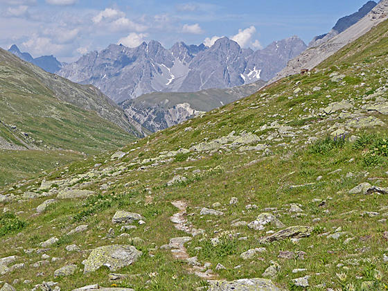
Ascend the Sesvenna Valley to a rocky, meadow-clad bowl accompanied by fine views of the peaks and summits rising to the west. Extend the hike with a very steep climb to Sesvenna Pass with stunning vistas of the rugged Sesvenna cirque and the summits towering above the S-charl Valley, the Swiss-Italian border and beyond.
See Trail Detail/Full Description
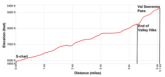
- Distance: 8.6 miles (round trip) to Val Sesvenna
10.2 miles (round trip) to Fuorcla Sesvenna - Elevation: 5,930-ft. at Trailhead
8,071-ft. at Val Sesvenna
9,249-ft. at Fuorcla Sesvenna - Elevation Gain: 2,141-ft. to Val Sesvenna
3,319-ft. to Fuorcla Sesvenna - Difficulty: moderate-strenuous
- More Hikes in:
Scuol / Eastern Switzerland
Why Hike Val Sesvenna and Fuorcla Sesvenna
This is really two hikes in one. The first segment of the hike ascends to Alp Sesvenna and then travels up a secluded valley with great views of nearby peaks and the summit rising above the S-charl Valley. A meadow-clad bowl beneath a very steep wall near the head of the valley marks the end of this segment and is the turnaround point for many hikers.
The second segment of the hike requires a very steep climb up the wall. The effort is rewarded when the trail crests the wall and views open to Lake Sesvenna nestled in a stark basin beneath a photogenic cirque anchored by Piz Sesvenna. A final climbs leads to Fuorcla Sesvenna, a saddle on a high ridge on the north side of the cirque. From the pass panoramic views encompass the cirque, the peaks towering above the S-charl Valley and the summits rimming the Swiss-Italian border and beyond.
The climb up the wall is very steep and is only recommended for sure-foot hikers. There is a lot of loose rock, so take your time. Trekking poles are highly recommended, especially for the descent on the return leg of the hike.
This trail is shared by mountain bikes but is considered a very difficult bike route due to the climb/descent of the wall. As such, you will probably see few if any bikes along the path.
Elevation Profile

Support our Site | |
Trail Resources
Trail Detail/Full Description / Trail Photo Gallery / Trail Map
Basecamp(s) Information:
Scuol
Region Information:
Eastern Switzerland
Other Hiking Regions in:
Switzerland

