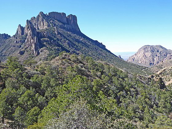
Casa Grande and Vernon Bailey Peak
This popular hike ascends to Casa Grande’s scenic east ridge and then climbs atop the ridge extending northwest from Crown Mountain West for superb views of the Chisos Mountains along with Juniper and Pine canyons.
- Distance: 2.0 - 4.8 miles (RT)
- Elevation: 5,730-ft. at Trailhead
Maximum elevation - 6,850-ft. - Elevation Gain: 1,120-ft.
- Difficulty: moderate
- Basecamp: Big Bend
- Region: Texas Parks
Trail Description - Lost Mine
It’s hard to beat the scenic bang for the miles hiked on this popular trail that ascends to a dramatic ridge with panoramic views of the Chisos Mountains. The steady climb to the destination is on moderate grades, except for one short, steep section. The last two-thirds of the hikes are exposed to the sun, so take plenty of water.
The Lost Mine trail was named after the legend of the Lost Mine of the Chisos. According to the legend Spanish explorers discovered a silver and gold mine here and forced the local Chizo tribe to work the mine. The Chizo’s revolted, killed all the Spanish and sealed the mine. No ore bearing rocks have ever been discovered in the area so the story remains a legend.
Note: If you are new to Big Bend and the Chisos Mountains I recommend the illustrated guide, available at the parking area, which points out plants, trees and points of interest along the hike.
From the parking area, just below the south side of Panther Pass (see driving directions below), a paved walkway makes a short, steep ascent to the beginning of the unpaved trail. The well maintained dirt path now ascends on moderate grades through juniper, pine and oak trees along the north facing slopes of Casa Grande.
Along the way enjoy views of the rugged ridge rising to the north across Green Gulch. As you gain elevation views open west to Mount Hoffman, Peak 6905 and Vernon Bailey Peak. These peaks rise about the north side of the Basin, a circular valley surrounded by the rugged Chisos Mountains. Soon the summit of Casa Grande comes into view.
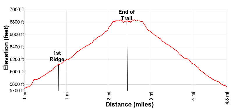
At 0.8 miles the trail crests a saddle on the ridge that extends east from Case Grande and rims the head of Juniper Canyon, to the south, and Green Gulch, to the west. From the ridge enjoy terrific views of the surrounding area. Casa Grande and Toll Mountain rise to the west/southwest. To the northwest are the peaks towering above the north side of the Basin. To the southwest views extend down the length of Juniper Canyon to the Chihuahuan desert.
Note: A boot beaten path ascends west along the ridge crest toward Casa Grande to a notch below the summit block where a route scrambles to the top of the peak. The unmarked trail may be closed certain times of year to protect nesting peregrine falcons. Check trail conditions and possible closures at the Chisos Visitor Center before setting out on this route.
The ridge is a good turn around point for parties looking for a shorter hike (1.6 miles round-trip). I strongly recommend continuing beyond the saddle.
From the saddle the grade steepens a bit as the trail ascends switchbacks up slopes clad in scrub growth and pockets of trees accompanied by fine views of Casa Grande and Toll Mountain. Turn around and look west to see Carter Peak, a pointy summit to the left (south) of Vernon Bailey Peak. The Window, a popular destination in the Basin, is located in gap the between the two peaks.
At 1.9 miles the trail briefly climbs steep grades up the final set of switchbacks to the top of a ridge at 2.1 miles. The ridge, extending northwest from Crown Mountain West, separates Pine and Juniper Canyons. Here the grade abates and grand views open in all directions.
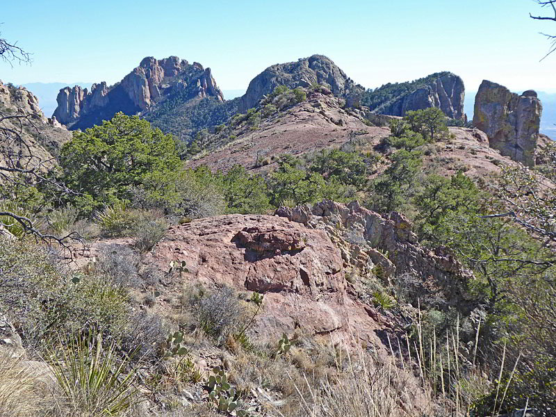
Dominating the views to the northeast are the rugged slopes and crags of Lost Mine Peak (7422-ft.). Casa Grande and Vernon Bailey Peak are seen to the west while Toll Mountain and the Chiso complex fill the skyline to the southwest. Crown Mountain towers above the ridge to the southeast. On a clear day distant views extend south/southeast to the Chihuahuan desert.
The undulating trail now heads southeast across the broad ridge, dipping into a shallow draw and then climbing back out again. The path then crosses slickrock heading toward the formations at the end of the ridge. Near the end of the trail the path passes an impressive monolith called the Elephant Tusk, rising along the right (west) side of the ridge.
The path ends a 2.4 miles where we enjoy more superb views of the surrounding peaks along with upper Pine Canyon (to the east/southeast) and Juniper canyon (to the west/southwest). Past this point the ridge descends steeply.
When you are done enjoying the views turn around and retrace your steps, enjoying the fine views on the return trip to the trailhead.
Elevation Profile
Driving Directions
From the Big Bend National Park Headquarters at Panther Junction: From Panther Junction, at the intersection of the Persimmon Gap Road and the West Entrance Road, head west on the West Entrance (Gano Springs) road toward Basin Junction for 3.2 miles. Turn left on the Chiso Basin Road and follow the road for 5.1 miles to the Lost Mine Trailhead parking area, located on the south side of the road. The parking area is past mile marker 5, a short distance beyond Panther Pass. If you continue along the Chiso Basin Road it drops down the Basin to the Chiso Mountain Lodge area.
This small parking area for this very popular trail fills quickly. Many people only hike the first mile of the trail before turning around, so there is a reasonable amount of turnover in the parking lot.
From the Chisos Mountain Lodge area: Head northeast on Chisos Basin Road for 1.4 miles to the Lost Mine Trailhead parking area on the south side of the road. This parking lot is just before Panther Pass. This small parking area for this very popular trail fills quickly. Many people only hike the first mile of the trail before turning around, so there is a reasonable amount of turnover in the parking lot.
Trail Resources
- Trail Photo Gallery
- Trail Maps
- Basecamp(s) Information: Big Bend
- Region Information: Texas Parks
- Other Hiking Regions in: Texas