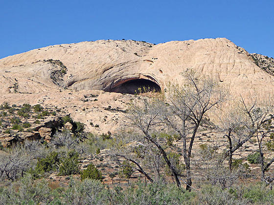
Fish Mouth Cave from the trailhead
Four archaeology sites, some rock art and an impressive large and deep alcove lure hikers up a short, narrow canyon off the Lower Butler Wash Road.
- Distance: 1.9 miles (RT)
- Elevation: 4,820-ft. at Trailhead
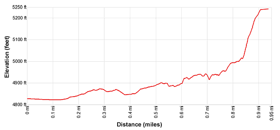
Maximum elevation - 5,240-ft. - Elevation Gain: 420-ft.
- Difficulty: easy-moderate
- Basecamp: Bluff / Bears Ears NM
- Region: Southeast Utah
Trail Description - Fish Mouth Cave
Comb Ridge is a stunning sandstone ridge of steeply tilted rock layers called a Monocline, a step-like fold in the rock strata. The ridge runs north-south for approximately 80 miles from Utah’s Abajo Mountain to Kayenta, Arizona. The jagged appearance of the ridge is similar to a rooster’s comb, hence the name.
The Lower Butler Wash Road, paralleling the base of the ridge to the east, offers access to the ridge and its drainages which are renowned for the numerous prehistoric sites, including ruins and rock art. Fish Mouth Cave is a recommended stop along the road. The canyon leading to the cave features a number of ruins and the cave itself, actually a very large, deep alcove, is fun to explore.
The biggest challenge when visiting the sites along Butler Wash is finding the correct trailhead. There are no signs marking turnoffs to the various drainages. Fish Mouth Cave, visible from the road, is actually one of the easier trailheads to find. When looking for trailheads your best bet is to religiously keep track of your mileage as you progress up or down the road. (See the driving directions below for more information.)
The hike to Fish Mouth Cave starts on an old dirt road located at the northwest end of a parking area. (See driving directions below.) Two brown BLM mylar stakes block wheeled vehicles from continuing on the road. The old road briefly parallels a wood/barb wire fence and then curves left (southwest). After 0.1 miles a mylar marker indicates where the trail turns west and crosses Butler Wash. A second marker reminds trail users that wheel vehicles are not allowed in the canyon.
The trail now heads west and enters the mouth of a canyon. Follow the boot beaten path as it travels along the north side of the wash. At 0.2 miles remnants of walls mark the site of the first ruin on this hike. Faint rock art is found on the walls near the ruins.
Beyond the ruin the trail soon curves to the left (south) and travels through some trees before turning back to the right (west) and entering the narrow canyon leading to Fish Mouth Cave.
After walking a little over 0.5 miles an alcove with the second set of ruins is seen along the north side of the canyon. This is the largest set of ruins in the canyon. Chains restrict access to a section of the ruin. Here plaster can be seen on some of the remaining interior walls. Please respect the closure.
When visiting the ruins in Fish Mouth Cave canyon please treat all the archaeology you discover with reverence and respect so that it may be enjoyed by future generations. Do not sit, climb or step on the walls of any structures or attempt to enter the structures. Leave any pot shards, corn cobs or other relics where you found them. Remember that rock art is extremely fragile and easily damaged. Never touch rock panels as the oil on your fingers can speed the erosion of the rock art. Do not vandalize the panels by taking latex mold prints or rubbings from rock art or adding modern additions. Please see the Tips for Enjoying and Preserving Archaeology Sites for more information.
Reach the third ruin, again located in a low alcove along the canyon’s north wall, at 0.6 miles. There are several well preserved/restored walls in this ruin. A short distance beyond these ruin is another set of structures in an alcove along the south wall.
The remains of additional structures can see beneath the low alcoves to the west (up canyon) beyond the third ruin. Most of these structures have been reduced to rock piles.
At 0.8 miles the route climbs up and over an expanse of slickrock, passing beneath a few small alcoves that look promising but do not contain any ruin. Along the way views open to Fish Mouth Cave at the head of the canyon.
A slight descent from the slickrock leads to the wash beneath the cave. Exploring the cave, actually a large, deep alcove, requires a steep climb up rocky slopes. Small ruins are tucked beneath the overhangs near the mouth of the cave. In addition to graffiti, you will find a nice set of reverse hand prints along the wall of the cave. There are also several large stones used for grinding and sharpening knives. It is unclear if there were ever ruins within the cave -- yet another mystery along the Lower Butler Wash road.
When you are done exploring the cave retrace your steps to the trailhead.
Elevation Profile
Driving Directions
The surface of Utah County Road 262, the Butler Wash Road, is packed dirt with sections of slickrock. The road can be rutted, sandy and rough in place. Under good conditions the road is passable with a 2WD vehicle if driven carefully. High clearance or 4WD is better.
From Bluff: Drive southwest on US-191 S for 4.2 miles. Where US-191 turns south continue straight ahead on US 162 for 0.9 miles and turn right on County Road 262 / Lower Butler Wash Road. The road is located between mile posts 41 and 40 and is across from the Bluff Airport Road (County Road 269A). Almost immediately reach a gate across the road, secured by a chain. Make sure you close the gate after passing through. Drive 12.7 miles north to a spur road on the left [~GPS location: 37.427964, -109.628468]. Turn left onto the spur and drive a short distance to a parking area. The Cave’s mouth is clearly visible from the parking area. Note: if you pass a wood/barb wire fence along the Butler Wash Road you have gone too far. Turn around and make the first right to find the trailhead for Fish Mouth Cave.
From Mexican Hat: Drive east on US-163 for 19.6 miles and turn left on County Road 262 / Lower Butler Wash Road. The road is located between mile posts 41 and 40 and is across from the Bluff Airport Road (County Road 269A). Almost immediately reach a gate across the road, secured by a chain. Make sure you close the gate after passing through. Drive 12.7 miles north to a spur road on the left [~GPS location: 37.427964, -109.628468]. Turn left onto the spur and drive a short distance to a parking area. The Cave’s mouth is clearly visible from the parking area. Note: if you pass a wood/barb wire fence along the Butler Wash Road you have gone too far. Turn around and make the first right to find the trailhead for Fish Mouth Cave.
Trail Resources
- Trail Photo Gallery
- Trail Maps
- Basecamp(s) Information: Bluff / Bears Ears NM
- Region Information: Southeast Utah
- Other Hiking Regions in: Utah