Backpack: Big Sandy to Cirque of the Towers via Jackass Pass 
Distance: 18.0 miles (round trip)
Bridger and Popo Agie Wildernesses, Bridger-Teton and Shoshone National Forests, near Big Sandy in Wyoming's Wind River Range
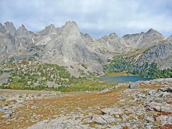
Lonesome Lake and the Cirque of the Towers
The shortest route to the Cirque of the Towers, an amazing spectacle of jagged peaks and spires rising over 12,000-ft. above Lonesome Lake, is via Big Sandy Lake and Jackass Pass trails.
- Distance: 18.0 miles
- Elevation: 0.0 miles - Big Sandy Trailhead (9,085-ft.)
5.5 miles Junction with Jackass Pass Trail (9,725-ft.)
7.7 miles to High Point above Arrowhead Lake (10,775-ft.)
8.2 miles to Jackass Pass (10,790-ft.)
9.0 miles to Lonesome Lake in the Cirque of the Towers (10,166-ft.) - Difficulty: strenuous
- More Hikes in:
Big Sandy / Wyoming's Wind River Range
Introduction
From the Big Sandy trailhead kiosk at the northeast end of the parking area, a wide path heads north on easy grades through trees and meadows along the west side of the Big Sandy River. Reach the junction with the Sedgewick Meadow trail branching right (east) at 0.6 miles. Here the Continental Divide Trail (#096) continues straight ahead toward Dad’s Lake. We turn right (east) at the junction on the trail signed for Sedgewick Meadow. Though not labeled, this is the most popular and shortest route to Big Sandy Lake.
Follow the trail as it parallels an oxbow bend in the river, crossing Meeks Creek at the top of the bend. A short distance beyond the trail makes a short, steep ascent up a hillside and then curves to the left (northeast) into the Big Sandy valley at 0.8 miles.
The trail now ascends the valley on easy to moderate grades through pine forest and intermittent meadows. At 1.3 miles the trail reaches the south end of a large meadow where views open to Warbonnet Peak (12,369-ft.), Mitchell Peak (12,482-ft.), Dogtooth Mountain (12,488-ft.), Big Sandy Mountain (12,416-ft.) and Schiestler Peak (11,642-ft.) rising above the head of the Big Sandy Valley.
Ascend the forested fringe along the northwest side of the lovely meadow with views of the Big Sandy River meandering along the valley floor. At 1.75 miles the trail reenter the trees and then climbs over two small rises to avoid steep sections of the river bank. Below the trail the river cascades down the rocky riverbed.
At 2.4 miles the trails starts an ascending traverse along the west side of the first of two large meadows. To the northeast are view of Big Sandy Mountain and Schiestler Peak. The river winds lazily along the valley floor.
Reach the junction with the trail to Diamond and V Lake branching left at 3.3 miles. We continue straight ahead, ascending on moderate grades through spruce-pine forest up the west side of a narrow draw, crossing three streams along the way.
At 4.7 miles the trail climbs over a low rise and then descends to the southwestern end of Big Sandy Lake (9,690-ft.) at 4.9 miles. The trail now travels through meadows and scattered trees along the lake’s western shore, crossing the creek draining Blue Lake at 5.3 miles.
The lakeshore enjoys great views of Haystack (11,978-ft.), Steeple (12,040-ft.) and East Temple Peaks to the southeast. Big Sandy looms above the lake to the east. Dogtooth Mountain and Mitchell Peak rise along the ridge to the northwest of Big Sandy Peak. Schiestler Peak towers above the lake to the south.
Reach the northwestern end of the lake at 5.5 miles. A short distance beyond is the unmarked junction with the trail branching left (north) toward Jackass Pass and the Cirque of the Towers. The trail to the right (east/southeast) travels through meadows around Big Sandy’s northern and eastern shores to the paths climbing to Clear, Deep and Black Joe Lakes.
The forested benches above the lakeshore harbor nice campsites with good views. Don’t expect solitude when camping at Big Sandy, the lake is extremely popular. There are also good campsites at Black Joe, Clear Lake and Deep Lake to the east/southeast of Big Sandy Lake.
Bears are a problem at Big Sandy Lake. Bear resistant canisters are recommended. Alternatively use approved techniques for hanging your food.
Many people setup a basecamp at Big Sandy and then day hike to Jackass Pass and the lakes to the east/southeast. This is a good option for hikers that don’t want to lug a backpack over the Jackass Pass trail.
To continue to Jackass Pass, turn left (north) at the unmarked junction and climb steep switchbacks up a hillside through meadows and scattered trees. Behind you are ever improving views of Haystack Mountain, Steeple Peak, East Temple, Temple and Schiestler Peaks. At 5.9 miles the grade abates as the trail ascends on easy grades through meadows along the west side of North Creek.
At 6.1 miles the path turns right (east) and crosses North Creek. On the east side of the creek the trail climbs a few switchbacks up a rocky hillside and then turns to the left (north). The trail now ascends on moderate grades through rocky meadows, across rock slabs and around outcroppings to a high point above the east side of North Lake (10,105-ft.) at 6.5 miles. Rock cairns help mark the route. As you climb enjoy views of Sundance Pinnacle (11,054-ft.) rising along the west side of the valley. Warbonnet Peak towers above the valley to the northwest.
From the highpoint, the trail follows a cairned route that descends along rock slabs and detours around large outcroppings and boulders as it travels high above the east side of North Lake. At times you may need to use your hands for balance as you negotiate steep descents around rock obstacles. Near the head of the lake the trail finally drops down to the rocky meadows along the lake’s eastern shore.
Follow the trail to the head of the lake where it turns left (west) and travels through marshy meadows, curving around the north end of the lake. At the northwest corner of the lake the trail climbs steep switchbacks up a rocky hillside and the turns right (north) into a narrow valley. The grade abates briefly before continuing its steep ascent through rocky meadows up the west side of the valley. As you ascend, turn around for fine views of East Temple Peak, Temple Peak, Schiestler Peak and Sundance Pinnacle.
Reach an unmarked junction at 7.2 miles. The trail branching to the left (northwest) leads to a route traveling through a boulder field along the west side of Arrowhead Lake (10,420-ft.). The boulder field is quite difficult to negotiate when wearing a backpack. I recommend taking the main trail, which branches right (northeast) and climbs steeply up alpine meadows growing amid scattered trees, boulders, rock outcroppings and slabs along the steep western flanks of Mitchell Peak (12,482-ft.).
Soon we leave the last of the trees behind as the trail climbs to a high point (10,775-ft.) above Arrowhead Lake at 7.6 miles. As you ascend turn around for great views of Haystack Mountain, Steeple Peak, Temple Peaks and Schiestler Peak towering above the Deep and Temple Lake drainages.
As you crest the high point you get your first views of the stunning Cirque of the Towers including Pylon Peak (12,378-ft.), the Watch Tower, Block Tower (12,210-ft.), Sharks Nose (12,229-ft.), Overhanging Tower (12,164-ft.), Wolfs Head (12,163-ft.), Pingora (11,884-ft.) and Bollinger Peaks (12,232-ft.). Warbonnet and Warrior Peaks (12,406-ft.) tower above the valley to the west.
From the high point the trail descends steeply down slabs, around outcropping and through meadows to an unmarked junction at the north end of Arrowhead Lake at 7.7 miles. Here we meet the other end of the trail that traverses the boulder field along the west side of Arrowhead Lake.
Turn right and climb the very steep trail through alpine meadows to Jackass Pass (10,790-ft.), a saddle on the south side of the Cirque between Mitchell and Warbonnet Peaks, at 8.2 miles. The Cirque of the Towers bursts onto the scene as you crest the pass. To the north Lizard Head Peak (12,842-ft.), Camels Hump (12,492-ft.) and the peaks around Texas Pass form a backdrop for Lonesome Lake (10,166-ft.), nestled in pretty meadows. Wolfs Head, Overhanging, Sharks Nose and Block Tower rise to the west of Pingora Peak. The Watch Tower and Pylon Peak complete the scene. Warbonnet and the Warrior Peaks tower above the south side of the cirque.
A sign at the pass reminds backpackers that there is no camping with a quarter mile of Lonesome Lake.
After taking in the views, descend steep switchbacks through rocky meadows, enjoying more great views of the Cirque along the way. Soon stunted conifers begin to appear and then scattered trees. Use trails branch off the main trail toward camp sites atop small benches and in the basin to the west of the trail.
The grade abates at 8.5 miles as the trail crosses a bench and then drops down to a junction along the south side of Lonesome Lake (10.166-ft.). The trail to the left (west) heads around the south side of the lake and links to trails climbing to campsites above the lake. We turn right (east) at the junction. Soon the trail crosses a minor inlet stream and then curves to the left (north) around the east side of the lake. Use trail branch off the main trail towards more camp sites.
Reach the outlet stream for Lonesome Lake at 8.9 miles. Rock-hop across the outlet stream. A short distance beyond the outlet (9.0 miles) is a beautiful viewpoint and trail junction along the east side of Lonesome Lake. From this viewpoint the Cirque of the Towers, an amazing spectacle of jagged peaks and spires rising over 12,000-ft., soars above Lonesome Lake. Prominent peaks visible from the lake’s eastern shore include Bollinger Peak, Pingora Peak, the Watch Tower, Pylon Peak, the Warriors and Warbonnet Peak.
From the junction the North Fork trail heads right (east) toward Lizard Head Meadows. Additional campsites are found along this trail. Straight ahead is a use trail that swings around the north shore of the lake to the route climbing to Texas Pass.
Camping can be found on the benches above Lonesome Lake and the upper lake basin to the southwest. Be sure to walk a quarter miles away from Lonesome Lake before you start searching for the perfect site. Use an existing campsite that is 200-ft. away from water sources and 100-ft. away from the main trails.
Bears are a problem at the Cirque of the Towers. Bear resistant canisters are recommended. Alternatively used approved techniques for hanging your food. The area can get quite crowded. Respect your fellow campers and keep the noise down in the evening.
If your schedule permits, I recommend spending a few days hiking around the Cirque. A relaxing day can be spent circling Lonesome Lake, a trip that offers great perspectives of the Cirque from a number of different angles. Other recommended day hikes include the steep route ascending to Texas Pass and a climb up the Lizard Head trail to visit the Bear Lakes and/or the Lizard Head Plateau. There are also routes leading to Hidden and Cirque Lakes that require some scrambling over boulder fields.
When you are finished enjoying the Cirque, retrace your steps to the trailhead for an 18-mile round-trip backpack (not including side-trips).
This backpack could be done in 1-night/2-days by well acclimated hikers in excellent shape but that is a ridiculous schedule allowing no time to enjoy the Cirque. Typical backpackers should allocate a minimum of 3-night/4-days with stops at Big Sandy Lake and the Cirque. I recommend allocating five or more days for the trip. The extra time will enable a more leisurely pace and allow time for day hikes, fishing and exploration.
Elevation Profile
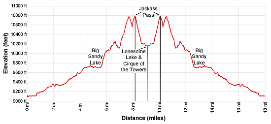
Mileage and Elevation Detail
| Miles | Elevation | Destination | |
|---|---|---|---|
| 0.0 | 9,085-ft. | Big Sandy Trailhead | |
| 0.6 | 9,120-ft. | Junction with Sedgewick Meadow/Big Sandy Trail (turn right) | |
| 3.3 | 9,500-ft. | Junction with Diamond and V Lakes Trail | |
| 4.9 | 9,690-ft. | Southwest end of Big Sandy Lake | |
| 5.5 | 9,725-ft. | Junction with Jackass Pass Trail (bear left) | |
| 7.7 | 10,775-ft. | High Point above Arrowhead Lake | |
| 8.2 | 10,790-ft. | Jackass Pass | |
| 9.0 | 10,166-ft. | Lonesome Lake | |
| 9.8 | 10,790-ft. | Jackass Pass | |
| 10.3 | 10,775-ft. | High Point above Arrowhead Lake | |
| 12.5 | 9,725-ft. | Junction with Big Sandy Trail (bear right) | |
| 13.1 | 9,690-ft. | Southwest end of Big Sandy Lake | |
| 14.7 | 9,500-ft. | Junction with Diamond and V Lakes Trail | |
| 17.4 | 9,120-ft. | Junction with Continental Divide Trail (turn left) | |
| 18.0 | 9,085-ft. | Big Sandy Trailhead |
Trailhead Driving Directions
The Big Sandy Trailhead is located in the southern Wind River Range next to the Big Sandy River.
Directions from Pinedale: From the intersection of Pine Street (US 191) and North Tyler Ave (the Pinedale Tourism office is located on the northeast corner) in Pinedale, WY, drive south on Highway 191 for 11.7 miles and then turn left (east) on WY-353. After 15.5 miles you will notice signs referring to the road as the Big Sandy-Elkhorn Road and after 18 miles the paved road will change to a good packed dirt/gravel surface.
Shortly after the pavement ends go straight through a junction, and drive south crossing the Big Sandy River (Buckskin Crossing). Follow the road for a total of 27.3 miles. Shortly after crossing the Big Sandy River you will reach a junction with the Lander Cutoff Road (the next junction). Turn left on the Lander Cutoff Road. There is a wood sign at the intersection pointing toward the Big Sandy trailhead.
Drive 7.0 miles on the Lander Cutoff Road and then turn left on the Big Sandy Opening Road. Here you will see a sign for the Big Sandy Campground and trailhead. The road now deteriorates and narrows. Blind corners and lush foliage along the road make it hard to see ahead. Drive carefully, following the rocky, rutted road for 9.8 miles to a "Y" intersection. Bear right at the intersection to continue along the Big Sandy Opening Road (Forest Service Road 850). (The road branching to the left leads to the Big Sandy Lodge and Mud Lake.) Follow the road for 0.8 miles to the trailhead parking area, equipped with an outhouse.
Allow an hour and a half to reach the trailhead from Pinedale. The parking area is too small for the number of backpackers visiting the area during the height of the summer. If the parking area is full, find a safe place to park off the access road.
I recommend a high clearance vehicle to reach the trailhead. Passenger cars can make it OK if driven carefully. Check at the Pinedale ranger station before starting your trip to learn about current road and trail conditions. The Ranger Station is located to the east of the Ridleys Grocery Store on US 191 (Pine Street in Pinedale). The entrance to the ranger station is on the Fremont Lake Road. (You can also reach the parking area for the ranger station by driving east through the Ridley’s parking lot.)
This trailhead is remote, so be sure to have a full tank of gas. The dirt road become slippery when wet. The campground at the parking area is tiny, with only 4 sites. I would not plan on camping at the trailhead before starting your backpack.
Trail Resources
Trail Photo Gallery / Trail Map
Basecamp(s) Information:
Big Sandy
Region Information:
Wyoming's Wind River Range
Other Hiking Regions in:
Wyoming