Backpack: Hailey Pass - Lizard Head - Cirque of the Towers Loop
Segment 4: Valentine Lake to Cirque of the Towers via Lizard
Distance: 10.3 miles (one way)
Popo Agie Wilderness, Shoshone National Forest, near Big Sandy in Wyoming's Wind River Range
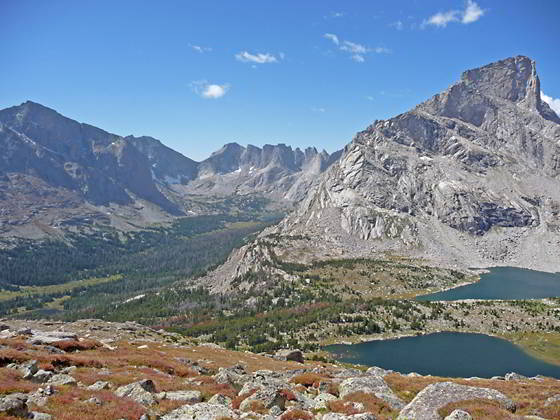
Lizard Head Peak, Bear Lake, Cirque of the Towers and Lonesome Lake
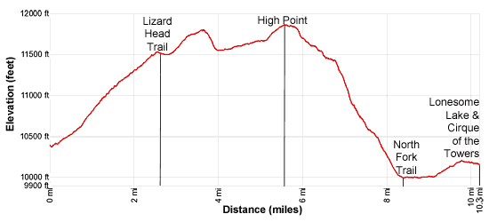
- Distance: 10.3 miles
- Elevation: 0.0 miles to Valentine Lake (10,399-ft.)
2.7 miles to Junction Lizard Head Trail (11,525-ft.)
5.6 miles to High Point Lizard Head Trail (11,864-ft.)
8.3 miles to Junction North Fork Trail (10,025-ft.)
10.3 miles to Lonesome Lake in the Cirque of the Towers (10,166-ft.) - Difficulty: strenuous
- Basecamp: Big Sandy
- Region: Wyoming's Wind River Range
Valentine Lake to Cirque of the Towers via Lizard Description
This segment of the loop crosses the tundra-clad Lizard Head Plateau with spectacular views of the southern Wind River peaks. Don’t attempt this trail unless you have good weather. A 5.5 mile segment of the trail travels above timberline at an average elevation of 11,500-ft. As you cross the plateau there is literally no place to hide in the event of a thunderstorm.
I have crossed the plateau on many occasions, always getting an early start to beat the afternoon thunderstorms, a frequent occurrence in the Rocky Mountains. On one of my crossings I got caught in a fast moving, violent thunderstorm as I started the descent from the high point on the plateau to Lonesome Lake. It was a truly scary experience with ear-splitting thunderclaps overhead, howling winds and icy rain. Be smart, get an early starts and don’t push you luck if bad weather is threatening.
This description assumes you are starting from Valentine Lake, 1.1 miles above the junction of the Washakie and Bear Ears Trail near the South Fork of the Little Wind River. Valentine Lake and Little Valentine Lake, further up the trail, are popular overnight stops for backpackers planning to cross the plateau the next day.
From Valentine Lake head northeast on the Bear Ears Trail, climbing on easy to moderate grades through trees up the north side of the valley. Pass a signed junction with the Moss Lake trail, branching to the left (northeast), at 0.5 miles. We continue ascending on the Bear Ears Trail toward the Lizard Head plateau.
As the trail climbs the trees thin and views open to Cathedral Peak (12,236-ft.) towering above the cliffs to the southeast. To the west/northwest are distant views of Buffalo Head (11,717-ft.), Mount Washakie (12,524-ft.), Washakie Pass, Bernard Peak (12,193-ft.) and Chess Ridge.
At 1.2 miles the trail briefly curves to the right (south) as it ascends along a path chiseled into a steep, rocky hillside. To the south views open to Little Valentine Lake nestled in a rocky bowl beneath the cliffs of the Lizard Head Plateau. At the base of the hillside Valentine Creek meanders through a marshy meadow. To the northwest views open to Musembeah Peak (12,593-ft.) and the summits rising to the north of Grave Lake.
At 1.4 miles the trail curves to the left (east) and leaves the last of the trees behind as it ascends rocky meadows littered with willow thickets. Along the way pass a faint use trail (1.5 miles) descending to a knoll above Little Valentine Lake where there are some nice campsites.
Soon the trail starts switchbacking up rocky meadows on moderate grades. As you gain elevation Washakie and Grave Lakes come into view, set amid a backdrop of high peaks and sheer cliffs, to the west and northwest respectively.
Reach the top of the switchbacks at 2.2 miles. The trail now continues ascending on moderate grades through tundra to the plateau at 2.6 miles. Atop the plateau the path descends on easy grades across a bowl to a trail junction at 2.7 miles. Here the Bear Ears Trail turns left (north). We turn right (south) on the Lizard Head Trail, which descends on gentle grades to cross the nascent Valentine Creek at 2.8 miles.
Beyond the creek the trail climbs the north and then west facing slopes beneath Cathedral Peak to the second highest point (11,806-ft.) on the trail at 3.7 miles. As you ascend enjoy amazing views of an ever evolving panorama of the southern Wind River peaks. Mount Baldy and the peaks around Tepee Pass rise to the north. To the northwest are more incredible views of the peaks towering above the Grave and Baptiste valleys. You are now high enough to see the summits of Mount Bonneville and Pronghorn Peak rising beyond Mount Lander and Musembeah Peak. Closer at hand are the massive ridges and sheer cliffs of Buffalo Head and Chess Ridge. The huge ridge in the distance to the northwest is Robert’s Mountain.
As you reach the second highest point, the summits forming the stunning cirque around the South Fork Lakes spring into view. Mount Washakie, Washakie Pass and Bernard Peak are now visible to the west. The rugged summit of Cathedral Peak looms above the trail to the east while its neighbor, Peak 12012, dominates the skyline to the southeast. To the south the summits of Mitchell Peak (12,482-ft.), Dogtooth Mountain (12,468-ft.) and Big Sandy Mountain (12,416-ft.) peek above the vast tundra clad plateau.
After taking in the views, follow the trail as it drops on moderately steep grades into a bowl between Cathedral Peak and Peak 12012 at 4.0 miles. Rock cairns mark the trail, which fades at times as it crosses the tundra. Beyond the bowl the trail ascends on easy to moderate grades through an alpine wonderland with more glorious views.
At 5.1 miles the grade steepens as the path climbs toward the high point along the trail. As you ascend be sure to turn around for more great views of the peaks to the northwest. Near at hand, Lizard Head Peak towers to the southwest while the ridges and peaks rimming the South Fork cirque dominate the view to the west.
Reach the high point (11,864-ft.) on the trail at 5.6 miles. Here views unfold to the peaks defining the Continental Divide, including Mitchell Peak, Dogtooth Mountain and Big Sandy Mountain along the south side of the North Fork Popo Agie River valley.
From the high point the trail curves to the southeast as it descends on moderate grades along the west facing flanks of Windy Mountain. Along the way enjoy great views of the Monolith, an interesting tower rising above Papoose Lake to the south. To the west, Bear Lake is now in view at the foot of Lizard Head Peak.
At 6.7 miles the trail turns south and begins a very steep descent to Lizard Head Meadows at the foot of Windy Mountain. To the west views open to the Cirque of the Towers and Lonesome Lake. On a beautiful day photographers will be reaching for their cameras to capture the amazing scene of Lizard Head Peak and Bear Lake set against the backdrop of the Cirque and Lonesome Lake.
The steep trail demands your attention, making it hard to take in the views while descending. At 7.1 miles the trail hits the timberline and the descent gets a little bit easier, but is still very steep.
Reach the signed junction with the Bear Lake trail heading right (northwest) at 7.5 miles. We turn left (southeast) and continue descending on the Lizard Head trail. A short distance beyond the grades steepens as the trail drops down two long switchbacks to the signed junction with the North Fork Trail at 8.25 miles. Turn right (west) on the North Fork Trail toward Jackass Pass and the Cirque of the Towers. Heading left (east) leads to Pinto Park and the Dickinson Park trailhead.
Reach beautiful Lizard Head Meadows a short distance beyond the junction. Here the Cirque of the Towers forms the stunning backdrop for North Fork Popo Agie River meandering through the emerald green meadows carpeted with willow thickets.
The trail now arcs around the east and the north side of the meadows, crossing two streams at 8.6 and 8.7 miles. A section of this trail is often flooded by the first stream. Past the second crossing the trail travels through trees along the north side of the meadows. Nice campsites with great views of the Cirque are found in the wooded fringe to the south of the trail.
Reach the west end of the meadows at 9.1 miles. Here the trail climbs through trees on easy grades to the beginning of the bench cradling Lonesome Lake at 9.8 miles. For the next quarter miles you will find a few nice campsites in the forested fringe to the south of the trail. Be sure to camp 200-ft. from the river and 200-ft. from the trail.
The trail now descends on easy grades through trees and small meadows toward the lake. At 10.0 miles pass a sign indicating that you are within a quarter miles of Lonesome Lake. Remember that no camping is allowed within a quarter mile of the lake.
Reach the east shore of lovely Lonesome Lake (10,166-ft.) at 10.3 miles. From this viewpoint the Cirque of the Towers, an amazing spectacle of jagged peaks and spires rising over 12,000-ft., soars above Lonesome Lake. Prominent peaks visible from the lake’s eastern shore include Bollinger Peak (12,232-ft.), Pingora Peak (11,884-ft.), the Watch Tower, Pylon Peak (12,378-ft.), the Warriors (12,360-ft. and 12,406-ft.) and Warbonnet Peak (12,369-ft.).
Camping can be found on the benches above the lake and in the upper lake basin to the west. Don’t start searching for a site until you are sure you are a quarter mile from Lonesome Lake. Always use an existing campsite that is 200-ft. away from water sources and 200-ft. away from the main trail.
Bears are a problem at the Cirque of the Towers and Big Sandy Lake. Bear resistant canisters are recommended. Alternatively use approved techniques for hanging your food. The Cirque of the Towers is a popular place and can get quite crowded during the height of the summer. Respect your fellow campers by keeping the noise down at night.
If your schedule permits, I recommend spending a few days hiking around the Cirque. A relaxing day can be spent circling Lonesome Lake, a trip that offers great perspectives of the Cirque from a number of different angles. Other recommended day hikes include the steep route ascending to Texas Pass and ascending part way up the Lizard Head trail to visit the Bear Lakes. There are also routes leading to Hidden and Cirque Lakes that require some scrambling over boulder fields.
Return to Segment 3: Over Hailey Pass to Valentine Lake
Go To Segment 5: Cirque of the Towers to Big Sandy Trailhead via Jackass Pass
Elevation Profile
Backpack Segments
- Introduction: Hailey Pass - Lizard Head - Cirque of the Towers Loop
- Segment 1: Big Sandy Trailhead to Marms Lake
- Segment 2: Marms Lake to Hailey Pass Trail Junction
- Segment 3: Over Hailey Pass to Valentine Lake
- Segment 4: Valentine Lake to Cirque of the Towers Via Lizard Head
- Segment 5: Cirque of the Towers to Big Sandy Trailhead via Jackass Pass
Driving Directions to Big Sandy Trailhead
The Big Sandy Trailhead is located in the southern Wind River Range next to the Big Sandy River.
Directions from Pinedale: From the intersection of Pine Street (US 191) and North Tyler Ave (the Pinedale Tourism office is located on the northeast corner) in Pinedale, WY, drive south on Highway 191 for 11.7 miles and then turn left (east) on WY-353. After 15.5 miles you will notice signs referring to the road as the Big Sandy-Elkhorn Road and after 18 miles the paved road will change to a good packed dirt/gravel surface.
Shortly after the pavement ends go straight through a junction, and drive south crossing the Big Sandy River (Buckskin Crossing). Follow the road for a total of 27.3 miles. Shortly after crossing the Big Sandy River you will reach a junction with the Lander Cutoff Road (the next junction). Turn left on the Lander Cutoff Road. There is a wood sign at the intersection pointing toward the Big Sandy trailhead.
Drive 7.0 miles on the Lander Cutoff Road and then turn left on the Big Sandy Opening Road. Here you will see a sign for the Big Sandy Campground and trailhead. The road now deteriorates and narrows. Blind corners and lush foliage along the road make it hard to see ahead. Drive carefully, following the rocky, rutted road for 9.8 miles to a "Y" intersection. Bear right at the intersection to continue along the Big Sandy Opening Road (Forest Service Road 850). (The road branching to the left leads to the Big Sandy Lodge and Mud Lake.) Follow the road for 0.8 miles to the trailhead parking area, equipped with an outhouse.
Allow an hour and a half to reach the trailhead from Pinedale. The parking area is too small for the number of backpackers visiting the area during the height of the summer. If the parking area is full, find a safe place to park off the access road.
I recommend a high clearance vehicle to reach the trailhead. Passenger cars can make it OK if driven carefully. Check at the Pinedale ranger station before starting your trip to learn about current road and trail conditions. The Ranger Station is located to the east of the Ridleys Grocery Store on US 191 (Pine Street in Pinedale). The entrance to the ranger station is on the Fremont Lake Road. (You can also reach the parking area for the ranger station by driving east through the Ridley’s parking lot.)
This trailhead is remote, so be sure to have a full tank of gas. The dirt road become slippery when wet. The campground at the parking area is tiny, with only 4 sites. I would not plan on camping at the trailhead before starting your backpack.
Trail Resources
- Backpack Intro
- Segment Photo Gallery
- Segment Map
- Trailhead(s) Information: Big Sandy
- Region Information: Wyoming's Wind River Range
- Other Hiking Regions in: Wyoming