Lake Louise 
Distance: 4.6 miles
Fitzpatrick Wilderness, Shoshone National Forest, near Dubois in Wyoming's Wind River Range
Lake Louise
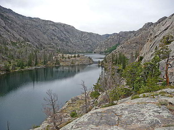
A short hike through a rugged landscape leads to Lake Louise, a beautiful body of water nestled beneath the steep walls of the West Torrey Creek Canyon formed by Whiskey Mountain, to the north, and Middle Mountain, to the south.
- Distance: 4.6 miles (RT)
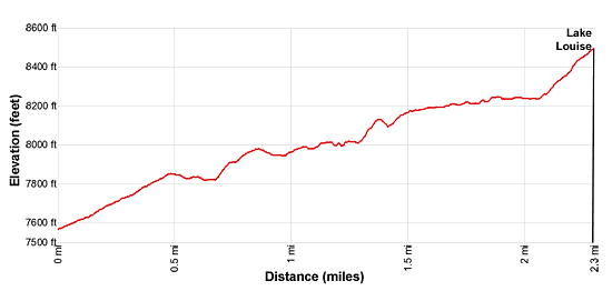
- Elevation: 7,595-ft. at Trailhead
Maximum elevation - 8,500-ft. - Elevation Gain: 905-ft.
- Difficulty: moderate
- Basecamp: Dubois
- Region: Wyoming's Wind River Range
Trail Description - Lake Louise
The trailhead for Lake Louise, shared by the Whiskey Mountain and Glacier trails, starts at the southwest end of the Trail Lake parking area. (See trailhead directions below.) The path heads northwest across dry sage-covered flats and then starts climbing moderate to moderately-steep switchbacks up the south facing slopes of Whiskey Mountain. There is little to no shade along the open slopes scattered with sage and junipers, making this segment of the walk very hot during the height of the summer. An early start is strongly advised.
After 0.5 miles reach a junction where the Whiskey Mountain Trail continues straight ahead and the Glacier Trail branches left (south). Turn left on the Glacier trail, which is also the trail heading toward Lake Louise. The path now descends on easy grades to a second junction at 0.7 miles, passing the boundary for the Fitzpatrick Wilderness along the way. At the junction the Glacier Trail turns left and descends to a bridge over East Torrey Creek. (I recommend taking a side trip to the bridge for views of the creek spilling down a narrow chasm.) We bear right on the signed trail for Lake Louise.
Beyond the junction the trail heads southwest above the west side of East Torrey Creek. After a short, moderately steep climb the path descends into a small cluster of trees at 0.9 miles, located adjacent to a pool along the creek. Beyond the trees the undulating trail ascends gradually above the creek, passing through a rocky landscape of granite knobs set amid pockets of sage and clusters of junipers and firs. The cliffs and rock outcropping along the south facing slopes of Whiskey Mountain rise above the trail to the north. East Torrey Creek rushes down the valley floor beneath the trail.
At 1.2 miles the creek curves to the left while we continue straight ahead. Look upstream to see an impressive waterfall along the creek. Two short-steep climbs now follow. At 1.6 miles the grade abates and the trail now ascends on easy grades through trees.
At 1.7 miles the path curves to the right (west), passes a small pond and then enters the West Torrey Creek drainage. The trail pass through a grove of conifers and small, marshy meadows at 1.9 miles before curving left (south). The lush scenery is short lived. Soon the trail is again traveling through a rocky landscape, ascending steeply above the west side of West Torrey Creek, a torrent tumbling down a rocky stream bed lined with conifers.
At 2.15 miles the trail reaches an unofficial junction. Here the trail curves to the right (west), climbing up a rugged, rocky slope rising above the north side of the creek and the outlet at the east end of Lake Louise. Reach an overlook above the east end of Lake Louise (8,382-ft.) at 2.3 miles. Steep, rugged canyon walls soar above the north side of the lake, making further travel challenging. A rocky knoll juts into the south side of the lake. Arrow Mountain is seen to the southeast towering above the East Torrey Creek Valley. The overlook is a great place to enjoy a picnic while taking in the scene.
Alternatively, at the unofficial junction at 2.15 miles, a use trail negotiates a rugged path along above the north side of the creek to a log jam near the lake’s outlet. Depending on conditions it may be possible to carefully cross the jam to the south side of the lake where there are some campsites. Use caution and don’t attempt the crossing during high water or other unsafe conditions.
When you are done enjoying the lake, retrace your steps to the trailhead.
This hike is popular with families and anyone looking for a nice, half day hike in Whiskey Mountain Basin. This hike is also a good option is the weather prevents hiking in the high country.
Elevation Profile
Driving Directions
From Dubois: From the corner of N 1st Street and US 26 in Dubois, drive 3.7 miles east on US 26 / US 287 and then turn right onto Whiskey Basin/Trail Lake Road. The turn is a short distance beyond the bridge crossing Jakeys Fork. Almost immediately turn left to stay on Trail Lake Road (aka Forest Service #411). (The turn to the right leads to the Fish Hatchery.) Follow the road for 9.1 miles to its end at the Trail Lake parking area. Here you will find the Glacier, Whisky Mountain, Lake Louise and Bomber Basin trailhead.
Note: Before reaching the end of the road there are left turns leading to a parking area for horse trailers and an overflow parking area.
Trail Resources
- Trail Photo Gallery
- Trail Maps
- Basecamp(s) Information: Dubois
- Region Information: Wyoming's Wind River Range
- Other Hiking Regions in: Wyoming