Backpack: New Fork Lakes to Island Lake & out Elkhart Park
Side Trip: Island Lake Backdoor
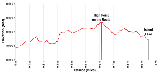
Distance: 1.0 miles (one way)
Bridger Wilderness, Bridger-Teton National Forest, near New Fork Lakes in Wyoming's Wind River Range
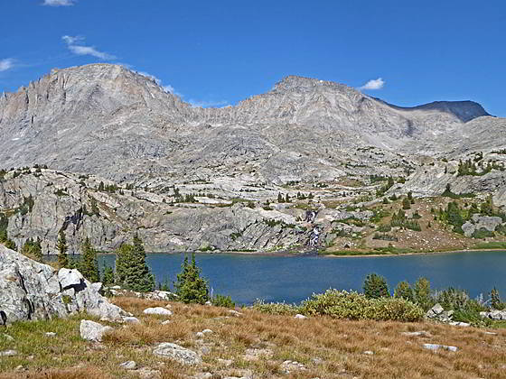
Fremont and Jackson Peak form the backdrop for Island Lake
- Distance: 1.0 miles
- Elevation: 0.0 miles at Junction with Highline Trail (10,420-ft.)
1.0 miles at Island Lake (10,425-ft.) - Difficulty: easy-moderate
- Basecamp: New Fork Lakes
- Region: Wyoming's Wind River Range
Island Lake Backdoor Description
The “Backdoor” to Island Lake, a route that requires off-trail navigation and route finding skills, offers a short cut to Island Lake from the south-bound Highline Trail. The route starts along the Highline Trail, 0.5 miles south of Fremont Crossing. The Crossing is where a sturdy wood bridge spans Fremont Creek.
On the south side of Fremont Creek the Highline climbs above the creek. Soon the grades eases as the trail travels through meadows scattered with trees. Pass a small tarn on your left and then climb over a low rise along the southwest side of an elongated pond.
Beyond the pond the path will pass a tiny tarn on your left and then a small pond as it starts ascending on easy grades. Ahead you will see a granite knob rising 175-ft. along the northeast side of the trail. As you walk beside the steep face of the knob the Highline curves to the right (south/southwest) away from the knob.
The unmarked “Backdoor route” branches to the left (southeast) at the point where the Highline Trail curves away from the knob. There is no visible trail at this point. The route ascends a draw on easy grades along the base of the knob. You will soon see traces of a boot beaten path that skirts a pond filled with rocks. Past the pond the route ascends over a low rise and then drops into a basin with a small tarn.
Travel around the north side of the tarn. The path fades as you pass through soggy meadows but will reappear at the northeast end of the tarn. Follow the trail as it drops down to a second tarn. In the meadows along the west side of the second tarn you may see a trail branching left (north). Ignore this trail. Our route makes a wide arc around the south side of the second tarn and then continues heading east as it climbs steeply up a rocky draw at 0.3 miles.
Soon the grade eases. The route continues heading east, passing to the south of a third tarn and to the north of a fourth larger tarn/pond. Along the way views open to Mount Lester, rising to the south.
Beyond the fourth tarn, a short, steep climb through meadows passes between granite knobs and leads to the high point along the route at 0.6 miles. A boot beaten path is now evident in the meadows as you drop down from the high point and skirt the north side of soggy meadows.
At 0.7 miles the trail starts climbing again on easy grades. Along the way views open to the top of Elephant Head. Soon the grade eases and views open to Elephant Head towering above Island Lake.
At 0.8 miles the trail starts descending toward the Island Lake basin. Soon the trail takes a jog to the right, traversing through meadows above a small pond above Island Lake’s shore. At 0.9 miles the trail drops on moderately grades down to the use trail running along the west side of Island Lake. Make note of where the “Backdoor” hits the trail along the lake, you might want to use it to exit the lake. Landmarks to note around the “Backdoor” trail are the nearby rocky knoll rising above the lake, a tarn to the south of the knoll and the dead snag near the junction.
Return to Segment 4: Highline Trail: Elbow Lake Basin to Indian Basin Trail
Go To Segment 5: Indian Pass Trail to Island Lake
Elevation Profile
Backpack Segments
- Introduction: New Fork Lakes to Island Lake & out Elkhart Park
- Segment 1: New Fork Trail: New Fork Lakes to New Fork Park/Palmer Lake Junction
- Segment 2: New Fork Trail: New Fork Park to Trail Creek Park via Lozier Lakes
- Segment 3: Highline Trail: Trail Creek Park to Elbow Lake Basin
- --- Side Trip: Peak Lake
- Segment 4: Highline Trail: Elbow Lake Basin to Indian Basin Trail
- --- Side Trip: Island Lake Backdoor
- Segment 5: Indian Pass Trail to Island Lake
- --- Side Trip: Titcomb Basin
- --- Side Trip: Indian Basin and Pass
- --- Side Trip: Island Lake Waterfall Hike
- Segment 6: Island Lake to Elkhart Park
Driving Directions to New Fork Lakes Trailhead
New Fork Lakes Trailhead: Located on the northeast shore of Lower New Fork Lake, this trailhead offers an alternative and less crowded access point to the northwestern Wind River range without the long drive to Green River Lakes.
Directions from Pinedale: From the intersection of Pine Street (US 191) and North Tyler Ave (the Pinedale Tourism office is located on the northeast corner) in Pinedale, WY, drive west on Highway 191 (West Pine Street) for 6 miles and then turn right on WY-352 toward Cora. Follow WY-352 for 14.3 miles and turn right on County Road 162, a dirt road signed for New Fork Lakes. Follow the road for 4.8 miles to the end of the road. Along the way the road name will change to New Fork Lakes Road/Forest Service Road 732/730. The New Forks Lake parking area is on the left. The trailhead is located at the northeast corner of the lot.
The 25.2 mile trip should take about 40 minutes. Passenger cars can typically make it to the trailhead without any problems.
Elkhart Park Trailhead: From the intersection of Pine Street (US 191) and North Tyler Ave (the Pinedale Tourism office is located on the northeast corner) in Pinedale, WY, drive east on Highway 191 (East Pine Street) for 0.3 miles and bear left onto Fremont Lake Road. Follow this road for 14.3 miles and turn right into the large parking area for the Elkhart Park/Pole Creek Trailhead. After the first 3.0 miles the road will turn into Skyline Drive/Forest Service Road 370740. The trailhead is located at the northeast end of the parking lot between the outhouse and the trailhead kiosk. It should take about 25 minutes to drive the trailhead. The last section of the road has some holes and uneven spots.
Trail Resources
- Backpack Intro
- Segment Photo Gallery
- Segment Map
- Trailhead(s) Information: New Fork Lakes
- Region Information: Wyoming's Wind River Range
- Other Hiking Regions in: Wyoming